Introduction to Kangra Agricultural System
- The Kangra Agricultural System (KAS) is located in the mid-altitudinal zone of the western Himalayan foothills, within the elevation range of 500–1500 meters above sea level. Geographically, the system is bounded to the north by the Dhauladhar range of the Lesser Himalaya (peaking at ~4200 meters) and to the south by the Shivalik hills (~1200 meters). Joindernagar in East and Rait in West formed the limit of Agricultural System.
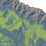
Kangra Outwash Plains and Kuhls
- The central part of the proposed site comprises extensive outwash plains, primarily developed through Pleistocene Glacial and fluvial activity. These plains have been categorized into three major de-positional systems—namely the Rihlu Fan, Kangra Fan, and Palampur Fan deposited by high-energy streams and melt water events (Srivastava, Rajak, & Singh, 2013, p. 138). Originally characterized by steep gradients, erratic boulders, poorly sorted sediments, and unstable drainage, these fan surfaces were not immediately suitable for intensive agriculture.

Conversion of Kangra Plains into Terrace Farm
- The transformation of these alluvial fans into stable, terraced agricultural zones was a result of prolonged and coordinated human intervention. Communities employed traditional engineering practices to reshape the terrain, including boulder clearance, surface leveling, and the construction of stone-reinforced terrace bunds. The integration of the gravity-based Kuhl irrigation network further enabled controlled water distribution, transforming the geomorphic units into viable agro-ecological zones.
Geological Timelime of Formation of Plains, (Srivastava, Rajak, & Singh, 2013)
● ~50 Myr ago: Formation of the Himalayan mountain range due to the collision of the Indian plate with the Eurasian plate.
● 11 Ma: Sedimentation in the Kangra basin began.
● 200 ka: Cessation of Upper Siwalik sedimentation.
● 100 ka: Late Quaternary fan building activity began.
● 78 ka: Formation of loess in proximal settings of the alluvial fans.
● 44 ka: Formation of loess in proximal settings continued.
● 30 ka: Formation of loess in distal settings of the alluvial fans.
● 20 ka: Formation of loess in distal settings continued.
● 75-65 ka and 50-35 ka: Reactivation of the Main Boundary Thrust (MBT).
● 19.9 ka to present: Deposition over the younger surfaces in the Kangra basin continued with intervening breaks and formation of paleo sols.
L’Horta de València agro-landscape
- The L’Horta de València agro-landscape evolved from a dynamic coastal plain characterized by seasonal marshes, fluvial channels, and alluvial sediments deposited by the Turia River. Originally composed of hydromorphic soils with high salinity and poor drainage, this environment was unsuitable for sustained agriculture without substantial human intervention. Over centuries, the landscape underwent a fundamental transformation driven by engineered water control and land reclamation strategies.
- The earliest known modifications can be attributed to Roman hydraulic engineering, which introduced primary irrigation channels. However, it was during the Islamic period (8th–13th century CE) that systematic landscape-scale transformation took place.
- A highly sophisticated gravity-fed irrigation network—based on diversion from the Turia River—was established, including a network of acequias (irrigation canals), azuds (weirs), and partidores (water distributors). These structures allowed for the redistribution of river water to otherwise poorly drain and saline soils, enabling year-round cultivation.
- Through these interventions, the natural coastal hydrology was reorganized into a spatially ordered agricultural matrix. The original wetland areas were systematically drained and parceled into rectangular plots (huertas), creating a mosaic landscape that maximized water efficiency and microclimatic advantages. Crucially, these landscape transformations were supported by robust socio-legal institutions, including the Tribunal de las Aguas, a customary court governing irrigation rights and water-sharing norms since the 10th century.
Conclusion
- Kangra Agriculture System represent complex interaction Between Geology,Geogrgaphy and Human. Over the centuries these plains has been converted into excellent Terrace Farm. Similarly L Horta of Spain also has deep historical root. Both system share many similarity. However Kangra Agriculture Sytem still far away from Global Recognition.
Source Book : https://archive.org/details/the-kangra-agricultural-system-a-giahs-perspective-on-heritage-and-resilience-1/page/n29/mode/2up Written by Pardeep Kumar, (jpardeep106@gmail.com)