| Item | 2023-24 |
| Geographical Area (sq. kms) | 55673 |
| Districts (Nos.) | 12 |
| Sub-Divisions (Nos.) | 81 |
| Tehsils/Sub-Tehsils (Nos.) as on 31.03.2024 | 186 |
| Development Blocks (Nos.) (31.03.2023) | 88 |
| Towns & Cities (Nos.) 2011 census | 59 |
| No. of Gram Panchayats (31.03.2024) | 3615 |
| Inhabited villages (Nos.) 2011 census | 17882 |
District wise map of Himachal Pradesh with Area:
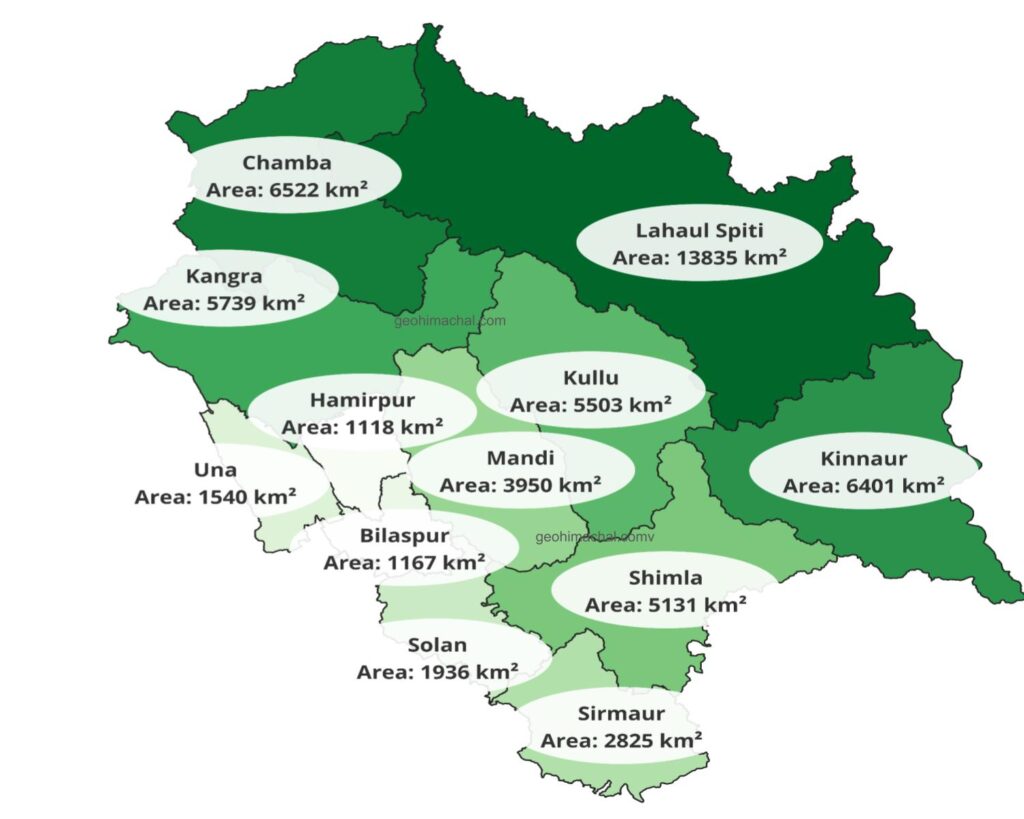
Key Observations from the Map explaining the District Areas and boundaries of Himachal Pradesh.
- Largest District: Lahaul-Spiti – 13,835 km², making it the biggest district in Himachal Pradesh by area.
- Smallest District: Hamirpur – 1,118 km², the smallest district by area.
- Other Large Districts: Kinnaur (6,401 km²), Chamba (6,522 km²), Kangra (5,739 km²), and Shimla (5,131 km²).
- Moderately Sized Districts: Kullu (5,503 km²), Mandi (3,950 km²), Sirmaur (2,825 km²), Solan (1,936 km²), Una (1,540 km²).
- Smaller Districts: Bilaspur (1,167 km²), Hamirpur (1,118 km²).
- Regional Balance: Northern and tribal districts like Lahaul-Spiti and Kinnaur are very large, whereas southern-central districts like Hamirpur, Una, and Bilaspur are tiny.
District-wise Boundary Count (approximate)
- Kangra – touches 6 districts (Chamba, Hamirpur, Mandi, Una, Kullu, Lahaul-Spiti, Largest number of boundaries in Himachal Pradesh.
- Mandi – 6 districts (Kullu, Kangra, Hamirpur, Bilaspur, Solan, Shimla).
- Chamba – 2 districts (Kangra, Lahaul-Spiti,
- Kullu – 5 districts (Mandi, Lahaul-Spiti, Kangra, Kinnaur, Shimla)
- Shimla – 5 districts (Kinnaur, Mandi, Solan, Sirmaur and Kullu.)
- Bilaspur – 4 districts (Mandi, Hamirpur, Solan, Una,
- Hamirpur – 3 districts (Kangra, Una, Bilaspur).
- Solan – 3 districts (Bilaspur, Sirmaur, Shimla).
- Sirmaur – 2 districts (Solan, Shimla)
- Una – 3 districts (Hamirpur, Kangra and Bilaspur).
- Kinnaur – Lahaul Spiti, Shimla and Kullu.
State Border of Himacahl Pradesh: Jammu and Kashmir, Ladhakh UT, Punjab , Hariyana, Uttrakhan and Even river boundary with Uttar Pradesh.
Solve MCQ
Which district shares boundaries with the maximum number of districts?
a) Mandi
b) Shimla
c) Kangra
d) Chamba
Answer: c) Kangra
Which of the following districts has the least number of neighboring districts?
a) Sirmaur
b) Una
c) Kinnaur
d) All of the above
Answer: d) All of the above (each has 2 neighbors within Himachal)
The largest district in terms of area in Himachal Pradesh is:
a) Chamba
b) Lahaul-Spiti
c) Kangra
d) Kinnaur
Answer: b) Lahaul-Spiti
Which is the smallest district of Himachal Pradesh by area?
a) Bilaspur
b) Hamirpur
c) Una
d) Solan
Answer: b) Hamirpur
Which district shares boundaries with both Uttarakhand and Haryana?
a) Shimla
b) Solan
c) Sirmaur
d) Una
Answer: c) Sirmaur
Which district borders both Ladakh and Tibet (China)?
a) Lahaul-Spiti
b) Kinnaur
c) Chamba
d) Kangra
Answer: a) Lahaul-Spiti
Arrange these districts in decreasing order of area: Hamirpur, Chamba, Kinnaur, Una.
a) Kinnaur > Chamba > Una > Hamirpur
b) Chamba > Kinnaur > Una > Hamirpur
c) Una > Kinnaur > Chamba > Hamirpur
d) Kinnaur > Una > Hamirpur > Chamba
Answer: a) Kinnaur > Chamba > Una > Hamirpur