Himalaya are youngest and highest mountain system of world. Himalaya has evolved from Tethyan sea to snow clade peak. Himalaya has experience the Ice age, Monsoon and hot climate. It Landform are still evolving and preserve the sign of Great Geological Drama. Despite all this there is very little emphasis on geotourism in Himachal in General and Himalayan states in Particular.
What is Geotourism
“Geotourism means tourism that focuses on the earth itself. It highlights landforms, rocks, rivers, mountains, soil, and the processes that shape them.In simple words, it is travel based on geology and landscape. People visit a place to understand how the land was formed, why it looks the way it does, and how nature and culture interact there.It includes guided walks, viewing points, geo-trails, geological parks, volcano sites, old river terraces, fossils, caves, and heritage landscapes.”
Potential Geotourism Site
Tethyan Sea Fossils of Subhathu
The Subathu area in Himachal Pradesh is famous because its rocks still hold the remains of an ancient ocean called the Tethyan Sea. About 55–50 million years ago, before the Himalaya fully rose, this whole region was under a warm, shallow sea. As the Indian plate moved north and collided with Asia, this sea slowly closed, and its marine life got trapped in sediments that later became rocks.Subhathu can be projected as Geotourism site. There is already Museum in Subhathu opened by Dr. Ritesh Arya.
Spiti Fossils
Spiti Valley in Himachal Pradesh is one of the best fossil regions in the world. The rocks here are 200–50 million years old and were once part of the Tethyan Sea. This means Spiti was underwater long before the Himalaya rose. These fossils tell the story of how the Himalaya formed. Spiti’s rocks show the sea life before the India–Asia collision and the slow closing of the Tethys Ocean.
Landform of Lahaul -Spiti
Spiti and Lahaul together form one of the most striking mountain landscapes in the Himalaya, shaped by ancient seas, powerful glaciers, and deep river erosion.
“Spiti shows dry, desert-like valleys, fossil cliffs, badlands, and sharp ridges carved from old Tethyan Sea rocks. Lahaul shows wide U-shaped valleys, cirques, moraines, and glacial lakes created by long, active ice movement.”
These landforms make the region a natural outdoor museum where visitors can learn how the Himalaya was built. This mix of scenery, fossils, glaciers, and culture gives Spiti–Lahaul very high potential for geotourism based on education, conservation, and community income.
Suketi Fossils Park
Suketi Fossil Park in Himachal Pradesh is one of the few places in India where ancient animal fossils are found right at the surface, showing life that existed millions of years before the Himalaya rose. The site preserves fossils of giant elephants, hippo-like animals, and early horses that lived in the Siwalik region. These remains, along with the natural landscape of the Markanda valley, make Suketi ideal for geotourism because visitors can see how rivers, climate, and landforms shaped past ecosystems.
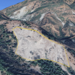
Glacier Plains of Kangra and Moraine
The vast plains of Kangra are actually old outwash surfaces built by rivers that once carried huge amounts of melt water and stones from ancient glaciers in the Dhauladhar range. As the glaciers advanced and retreated, they pushed out moraines and gravel, which the rivers then spread across the foothills to form wide, gentle plains. The scattered boulders, gravel beds, and terrace-like steps across Kangra still show the signature of those past glacial phases. This link between the flat plains and high mountain moraines gives Kangra strong potential for geotourism focused on glacial history and landscape evolution.(see here The Unique Geography of Kangra and evolution of Kuhls irrigation system)
Geotagging of Large Boulder, Traccing ancient Route of Glacier can add new dimension in district Tourismm iternaery.
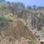
Visible Fault and Thrust as Tourist Sites
Visible fault fronts and thrusts can become geotourism spots because they clearly show how the Himalaya is still rising. Places where rock layers bend, break, or tilt make the Earth’s movement easy to understand for visitors. Good examples include the Main Boundary Thrust near Dharamshala, where tilted rocks are seen along the road to Shahpur, and the Himalayan Frontal Thrust exposures near Kala Amb and Paonta Sahib. With simple signboards and safe viewpoints, these locations can teach tourists about earthquakes, uplift, and mountain building while creating new income for local communities.
“Further Springs and waterfall can be intergerated with these fault and Thrust. For Example Bhagsu Waterfall in Dharamshal is comeout of Main Boundary Thrust. Similary Manikarn and Kasol both can be linked with Geotourism.“
Setting of New Rock Museum
By displaying rocks, fossils, minerals, and landform models from Spiti, Lahaul, Kinnaur, Kangra, and the Siwalik foothills, the museum can help visitors understand how the Himalaya rose from the ancient Tethyan Sea. Such a centre also preserves rare samples that might otherwise be lost and offers guided learning for students, researchers, and tourists. With simple interpretation material and community-trained geo-guides, the museum can become a key point in Himachal’s geotourism network, linking outdoor landscapes with scientific knowledge and local livelihood.