Location:
- Himachal Pradesh lies in the Western Himalaya. It extends between latitudes 30°22’ N to 33°12’ N and longitudes 75°47’ E to 79°04’ E. The state shares boundaries with Jammu and Kashmir & Ladakh in the north, Punjab in the west, Haryana in the southwest, Uttrakhand in the southeast, and Tibet (China) in the east. Reader Should note although Himachal Pradesh do not share direct border with Uttar Pradesh, a river formed boundary between two for roughly 2 Km.
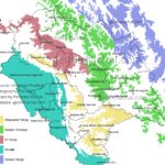
A ) Physiographic Division:
The state can be divided into four major physical divisions – Shivalik Hills, Lesser Himalaya, Greater Himalaya, and Trans-Himalaya.( For more Details )
Detail map of Physiographic Division of Himalaya
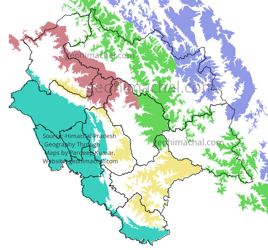
Shivalik Hills (Outer Himalaya):
- Found along the border with Punjab and parts of Haryana.
- Average height: 800 m to 1200 m.
- Prominent in Una, Hamirpur, Kangra (lower parts), Bilaspur, Solan, and Sirmaur.
- Not present in Shimla, Kullu, Kinnaur, and Lahaul-Spiti.
- Made of young sedimentary rocks like conglomerate, sandstone, silt stone, mudstone.
- Subject to erosion, with many seasonal gullies locally called Choos.
- Important ranges: Hathi Dhar, Sikander Dhar, Paprola Dhar.
- Locally called Manak Parbat or Tresses of Shiva.
- Una and Hamirpur lie entirely within this zone.
Lesser Himalaya (Middle Himalaya):
- Main ranges: Dhauladhar and Pir Panjal.
- Dhauladhar Range runs across Kangra and extends from Kinnaur to Chamba.
- Crossed by major rivers: Satluj at Rampur, Beas at Larji, Ravi near Dalhousie.
- Dhauladhar Mountain ranges has number of Important Passes:- Basodan,Minkiani, Indrahar, Talang, Jalsu etc.(Map of Important Passes of Himachal Pradesh.)
- Pir Panjal Range is higher than Dhauladhar.
- Enters Himachal from Pangi Valley (Chamba).
- Forms boundary between Chamba–Lahaul and Kullu–Lahaul.Famous Manimahesh Peak is also located on Pirpanjal.
- Pirpanjal also has many important Passes like- Sach Pass, Chobia Pass, Kugti Pass, Drati Pass etc.
- The Dhauladhar and Pirpanjal ranges meet at Barabhangal. There are many towering peak at this point like-Hanuman Tibba.
- Pir Panjal merges with the Greater Himalaya near Rohtang Pass. Many Important Rivers Such as Beas and Ravi Originate here.
Greater Himalaya (Himadri):
- Highest mountain zone of Himachal. It passes Through Lahaul Spiti, East of Kullu and Kinnaur. Greater Himalaya cause the Break in Himalaya and stop its advancement further.
- Greater Himalaya and Pirpanjal meet near Rohtang Pass in Kullu. This node Point is home to many Peaks and Glaciers.
- Average height: above 5000 m.
- Includes peaks, glaciers, and snow-clad ranges.
- Contains high passes like Kunzum Pass, and Shipki La.
- Chandrabhaga and Spiti are important rivers that originate here.
Trans-Himalaya (Cold Desert)
- Covers Lahaul-Spiti and Kinnaur. Zanskar is important range of it.
- It Touch Himachal Pradesh in Spiti and Transverse toward Kinnaur. Himachal Pradesh highest Reo Pargial also located here.
- High altitude desert region, very cold and arid.
- Average elevation: 3000 m to 5000 m.
- Sparse vegetation, barren landscape.
- Linked culturally and geographically with Tibet.
- Important ranges of Trans Himalaya in Himachal Pradesh is Zanskar Range,
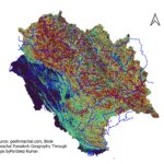
B) River System of Himachal Pradesh
Detail Article Rivers System of Himachal Pradesh ( Ravi, Chandrabhaga, Beas, Satluj and Tons) with MCQ( Part-1),Rivers System of Himachal Pradesh (Part 2)
Himachal Pradesh has vast network of small and large rivers, Ranging from consequent stream to antecedent streams. Density of such vast rivers network indicate the early youthfulness of Himalaya and its rivers network. River Like Satluj exist long before the existence of Himalaya itself. The evolution of these rivers are closely link with evolution of Himalayan ranges. Each river basin is separated from other river basin by either a mountain range or a crest of mountain.
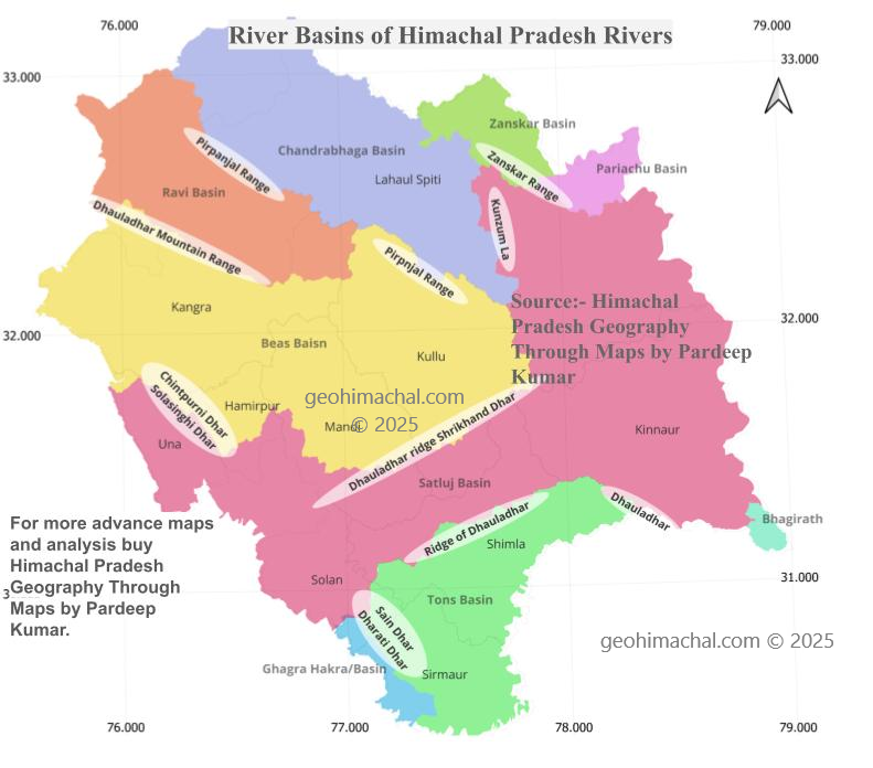
For example: In District Lahaul Spiti the Zanskar river basin is separated from Chandrabhaga river basin from Zanskar mountain range, similarly Kunzum mountain range separate the Chandrabhaga basin from Spiti river basin. Pirpanjal range which also formed the boundary between Lahaul Spiti and Chamba also formed the boundary between Ravi Basin and Chandra bhaga basin.
The Dhauladhar mountain range not only formed the boundary between Chamba and Kangra but also Ravi and Beas Bain. Similarly in Shivaliks hills, famous Chintpurni Dhar separates the Beas Basin from Satluj Basin in District Una.
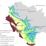
C) Area covered by Different River Basins.
Satluj River Basin is the Largest river Basin of Himachal Pradesh , it cover roughly drain 35.3% area of State , it is followed by Beas river which drain the 25.10% area of state. Chandrabhaga and Ravi each drain the 14% and 9.20 % of State area. All previously mention rivers are part of Indus river system. Two minor Sub -basins of Indus river in State are Zanskar ,which cover roughly 2.50% of State area and Pariachu river ,which is tributary of Satluj cover 1.50 % area of State. In Total Indus river cover roughly 48791 Sq Km, which 88.45% of State Area.
Tons river drained the part of Shimla, Solan and Sirmaur District, it drained roughly 10 % of State. Less mentioned and documented is Bhagirathi Basin, which drained 220.74 Sq Km (0.40 %) of State. In all Ganga Basin cover 5807 Sq Km of State , which is around 10.52 % of State area. ( Click to read Full Article )
D) Climate of Himachal Pradesh
Detail Article Here Climate of Himachal Pradesh.
Koppen has classified the Climate on the basis of Precipitation and temperature. Symbol A denote the Tropical Climate, B- Dry Climate, C- Temperate Climate, D- Continental Climate and E- Polar Climate.
- As we have already noticed than Himachal fall in Temperate Zone/Subtropical zone. Hence Symbol C- Denote the Most climate of Himachal Pradesh.
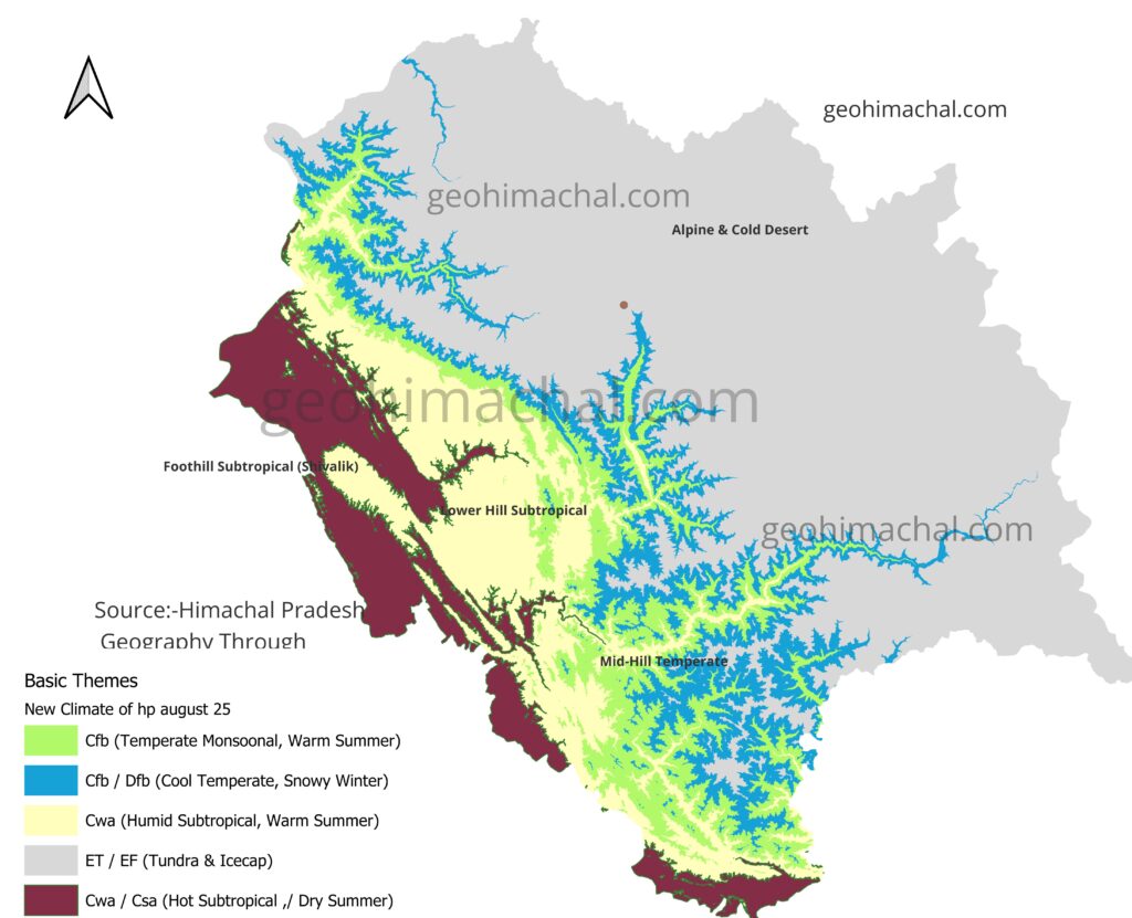
1. Foothill Subtropical Zone (Shiwalik)
- Location: Una, Hamirpur, Bilaspur, parts of Kangra and Sirmaur
- Climate: Hot summers (up to 40°C), mild winters, heavy monsoon rain
- Crops: Rice, maize, wheat, sugarcane
2. Lower Hill Subtropical Zone
- Location: Solan, Palampur, lower Shimla belt
- Climate: Warm summers, cool winters, abundant rainfall
- Crops: Maize, wheat, vegetables, pulses
3. Mid-Hill Temperate Zone
- Location: Shimla, Dharamshala, Mandi, parts of Chamba and Kullu
- Climate: Pleasant summers, cold winters with snowfall
- Crops: Apple, pear, plum, barley, wheat
4. Cool Temperate with Snowy Winters
- Location: Upper Kullu, higher Shimla ridges, parts of Kinnaur
- Climate: Short summers, long snowy winters
- Crops: Apple, peas, barley; important for horticulture and pastoralism
5. Alpine and Cold Desert (Tundra Climate)
- Location: Lahaul-Spiti, upper Kinnaur, Pangi valley
- Climate: Very cold, little rainfall, sparse vegetation
- Crops: Barley, buckwheat, peas; livestock rearing (yaks, goats, sheep)
6. Icecap and Glacial Zone
- Location: Peaks above 5,000 m (Shilla, Reo Purgyil, Bara Shigri Glacier)
- Climate: Permanent ice and snow, sub-zero temperatures round the year
- Crops/Activity: No agriculture; only glaciers and ice fields
E ) Forest of Himachal Pradesh
Detail article Latest Forest Survey/Report, 2023 of Himachal Pradesh ,with Advance Maps analysis.
1. Foothill Subtropical Zone (Shiwalik)
- Location: Una, Hamirpur, Bilaspur, parts of Kangra and Sirmaur
- Climate: Hot summers (up to 40°C), mild winters, heavy monsoon rain
- This area have low altitude and receive no rainfall but in monsoon it receive good rainfall. Popular trees in areas are Sal, Khair, Shisham, Chir Pine, mixed broad leaf, riverine species. The districts such as Una,Hamirpur and Bilaspur fall in this zone has very little forest area. The main Reason of Low forest area is High population density and increasing industrialization.
- This area is dominated by Open Forest and Moderate Dense forest. They lack very Dense forest.
- These forest area is also very prone to Forest fire.
- Simbarlbara National Park, Pong Dam Wildlife sanctuaries etc are important protected area.( see more Wildlife Sanctuaries and National Park of Himachal Pradesh.)
2. Lower Hill Subtropical Zone
- Location: Solan, Palampur, lower Shimla belt
- Climate: Warm summers, cool winters, abundant rainfall
- Crops: Maize, wheat, vegetables, pulses
- This belt is transition zone to higher temperate zone. Pine , Eucalaphytuc etc Dominate the region.
- This area also receive good rainfall in monsoon.
3. Mid-Hill and Cool Temperate Zone
- Location: Shimla, Dharamshala, Mandi, parts of Chamba , Kullu, higher Shimla ridges, parts of Kinnaur.
- Climate: Pleasant summers, cold winters with snowfall
- Crops: Apple, pear, plum, barley, wheat
- Popular Trees included Oak species, deodar, fir, spruce, blue pine, conifer mixes, mixed broadleaf-conifer.
4. Alpine and Cold Desert (Tundra Climate)
- Location: Lahaul-Spiti, upper Kinnaur, Pangi valley.
- Climate: Very cold, little rainfall, sparse vegetation.
- Crops: Barley, buckwheat, peas; livestock rearing (yaks, goats, sheep).
- Popular Trees included Birch, rhododendron, juniper, alpine shrubs, scrub, grasses.
5. Icecap and Glacial Zone
- Location: Peaks above 5,000 m (Shilla, Reo Purgyil, Bara Shigri Glacier)
- Climate: Permanent ice and snow, sub-zero temperatures round the year.
- Crops/Activity: No agriculture; only glaciers and ice fields.
- This zone has no vegetation.
F ) Disaster Profile of Himachal Pradesh
Detail Article Disaster Profile of Himachal Pradesh
Himachal is prone to very diverse disaster Profile.Total Area of Himachal Pradesh is about 55673 sq Km with Population around 70 Lakh. The overall density as census 2011 was 123 person per square Km, which now must be around 125 person per Sq Km. Physiography of State range from Plain to Higher Himalaya to Cold Desert, which pose wide diversity of threat. ( Details of Whole Disaster Plan can be sen here https://hpsdma.nic.in/)
Factors Affecting the Disaster Profile of Himachal Pradesh.
- Geology: It include Major Thrust , fault, Rocks strata, Slopes etc.
- Climate: It include intense rainfall, snowfall , Flood and Draught.
- Vegetation:- Like Forest, which is liked with slide and forest fire.
- Industrial:- Like Factory fire, Gas Leaks, Blasts in factory premises.
F) Demography of Himachal Pradesh
Detail Article Population Dispersal of HP
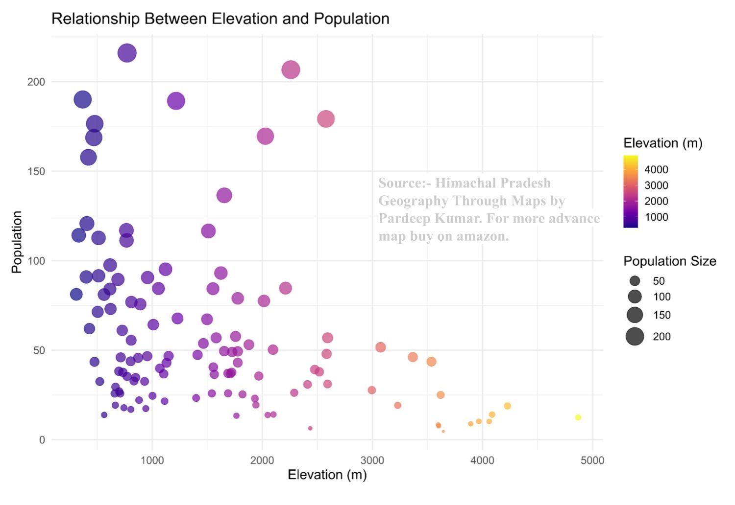
Population dispersal is complex Phenomena controlled by numbers of factors like climate, geography, economy and culture. Below mention maps will provide spatial understanding how human occupied the terrain. These maps are meant to Watch, Observe and understand. Such map understanding will help to solve many complex queries.
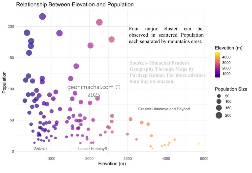
Interpretation of Above Map
In Himachal Pradesh, elevation strongly influences population distribution and settlement patterns. Most densely populated areas lie between 600 m and 1,800 m, where moderate slopes, fertile valleys, and favorable climate support agriculture and habitation. Towns such as Shimla, Dharamshala, and Mandi reflect this mid-altitude preference.
At elevations above 2,500 m, settlements become sparse due to harsh climate, shorter growing seasons, and limited accessibility. Only small hamlets and pastoral communities exist, often relying on seasonal migration. In contrast, areas below 500 m, such as parts of Una and Kangra districts, support higher population densities due to better connectivity and agricultural potential, though they experience hotter conditions.
Thus, elevation creates a clear gradient—from dense, permanent settlements in mid-altitude valleys to scattered, seasonal or nomadic habitations in high-altitude zones demonstrating how physiography shapes human geography in the region.
G) Cultural Geography
Himachal Pradesh has a rich cultural life shaped by its mountains, forests, and old village traditions. Every district celebrates its own fairs, sings its own songs, performs dances and dramas, and lives under the shadow of high peaks that define its landscape. These practices show how people stay connected to their land and to each other.
Bilaspur begins this cultural journey with the Markanda fair. The region has folk forms like Mohana songs and performances such as Swang and Dhaja that express community life. Chamba stands out for famous fairs like Minjar, Sui and Chatrari. The district is also known for folk songs like Ainchaliyan, Roopsu and Suhi Geet. People perform dances like Jhanjar and Dhangi, while dramas such as Jhanki and Hanter are part of festivals. Peaks like Narsingh Tibba and Gauri Devi ka Tibba add to the district’s beauty.
Hamirpur keeps traditions alive through the Holi Fair and Gasota fair. Cultural identity here is seen in forms like the Chandroli performance. In Kangra, the Panch Bhisham fair brings villages together. Songs such as Suhaag and Bidai Geet are sung during special occasions, and local performances like Bhagat and Chandroli show everyday stories. Cholang peak marks the natural charm of the district.
Kinnaur has one of the most colourful cultures in the state. Fairs like Japra, Beeshu, Dakreni, Phagli and Losar are celebrated with great enthusiasm. Traditional songs such as Chamb, Kyanag, Bakyang and Byangchoo express emotions of daily life. Dances like Cholamba, Yulba and Yando show the deep connection of people with their tribal roots. Kinnaur is also home to mighty peaks such as Kinner Kailash, Raldang, Shilla and Shipki.
Kullu is famous for the world-known Kullu Dussehra. Other fairs include Dungari, Nalwari and Sarhi Jatra. Folk songs like Laman fill the valleys, while dances such as Dili, Natio and Luddi make festivals lively. Peaks like Shirkhand, Shitidhar and Solang give the district its stunning backdrop.
Lahaul-Spiti, a cold desert, has fairs like Sissu fair, Phagli, Halda and Bumkhor. The area has traditional dances such as Shand, Langdarman and Garphi. Peaks like Shringla, Murangla, Gepang Geh and Mulkila rise high around the villages and monasteries.
Mandi preserves age-old fairs such as Shivratri, Kao, Mahunag and Mamail. The cultural life includes physical art forms like Thoda, Choohara and Mala, while dramas like Bathada and Banthara add storytelling to celebrations. Peaks like Shikari Devi, Kamrunag and Prashar surround the region.
Shimla’s fairs include Lavi, Tara Devi fair, Sipi fair and Jorna Jatra. Songs like Jhoori are popular, while dramas like Kariyala show local humour. Peaks such as Chanshal, Hatu, Kuppar and Shali Tibba define the district’s natural identity.
Sirmaur celebrates the Renuka fair and is known for songs like Jhoori. The region has dances such as Raasa, Gi, Juhri and Burah. These performances show how people celebrate seasons and festivals.
Solan has fairs like Sari and songs such as Jhoori that keep its culture vibrant. Una celebrates the Chintpurni fair, which brings thousands of devotees every year.
H ) Forest of Himachal Pradesh
As on 27/09/2025, Forest survey 2023 is the Latest forest Survey available to us. This survey is conducted by Govt of India and State Govt has no such survey. Upcoming section has many interactive maps that will make whole forest issue easy understand.
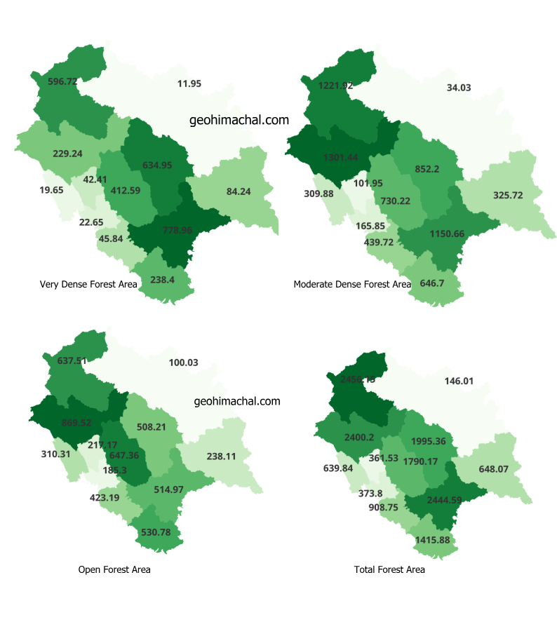
In Below given table you can see Forest area covers around 27.99 % of Himachal Pradesh Area. Out of this Moderate dense forest constitute the 13.08% of State area, Open forest constitutes around 9.31% of state area, and Very dense forest cover only 5.6% of State area. Thus it is the Moderate Dense forest which dominate the Himachal Pradesh forest Landscape.
Table showing Classification of Forest Based on ,Latest Forest Survey 2023.
| Class | Area (km²) | % of Calculated Area by SoI |
| VDF | 3117.6 | 5.6 |
| MDF | 7280.29 | 13.08 |
| OF | 5182.46 | 9.31 |
| Scrub | 308.69 | 0.55 |
| Total | 15580.35 | 27.99 |
I ) Economy of Himachal Pradesh
Himachal Pradesh is Primarily an agrarian rural state, where more than half of state population is dependent of Agriculture for employment. Tourism is growing industry in certain district, mining is prevalent in Shivalik and Plain bordering region. Hyrdo Electricity , Cement Industry and Pharma Industry are also contribute in state economy.
Land Distribution in State is uneven and sharply Shaped by British Era policies and post independence reforms. ( See more detail )
