Himachal Pradesh has very young Population. The shape of Population pyramid is wider at the base and gradually narrows at the top, indicating a larger young population with fewer elderly people. This is typical of a developing region where the birth rate is higher, leading to a broader base. The majority of the population falls within the younger and middle-age groups, with the largest numbers in the age ranges 10–24, suggesting a young population with potential for workforce growth. However these Statistics are almost 15 years old and much of population has been changed. (Read Population Dispersal here )
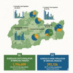
Statistical Table of Himachal Demography. ( Census 2011)
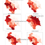
Maps of Himachal Demograhy.
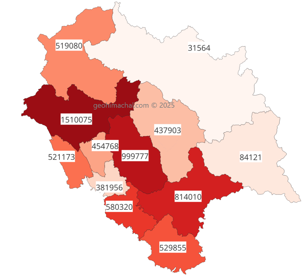
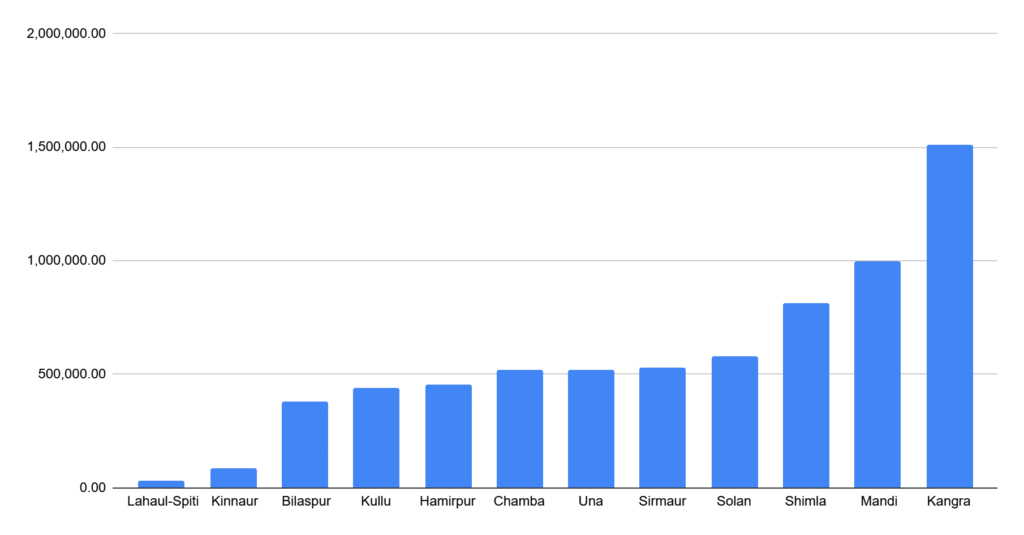
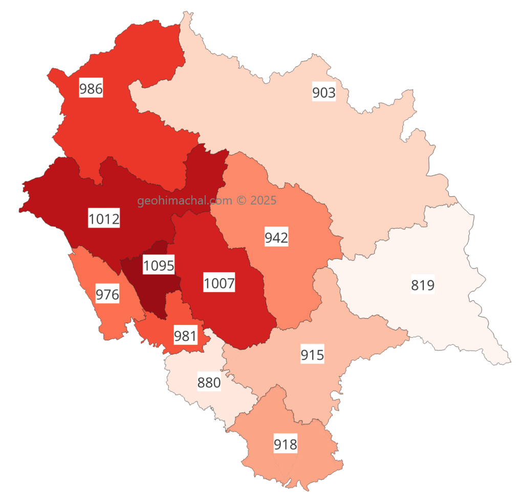
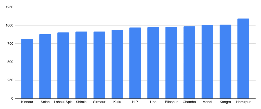
(A) Maps of Total Population of Himachal Pradesh.
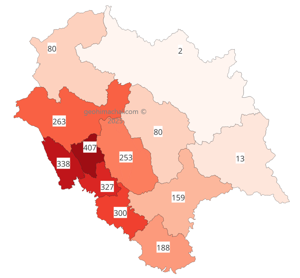
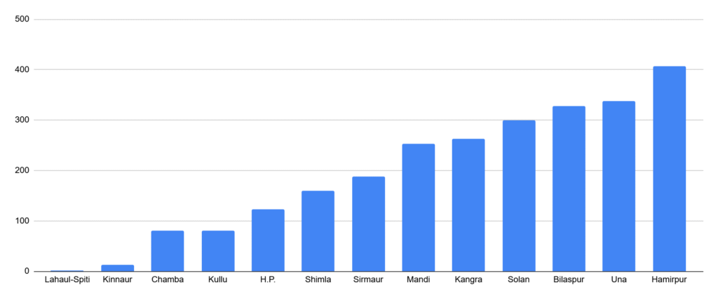
(B) Map of Population Density Himachal Pradesh
(C) Map of Sex Ratio of Himachal Pradesh.
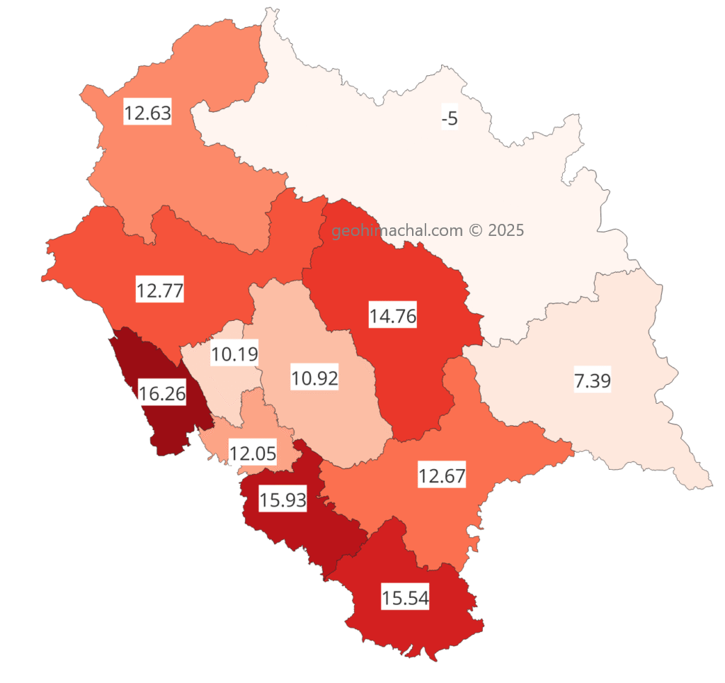
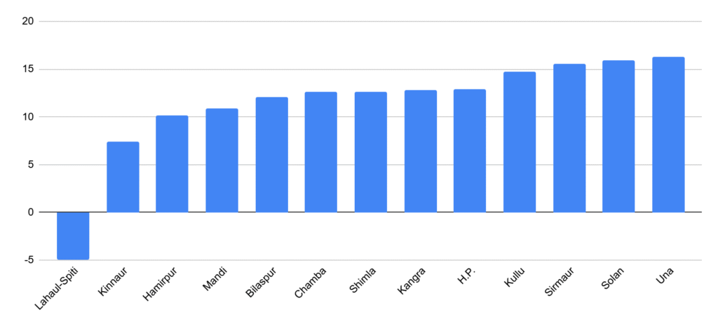
(D) Map of Deccenial Growth rate of Himachal Pradesh.
Solve the following MCQ Himachal Population and Demography
Multiple Choice Questions
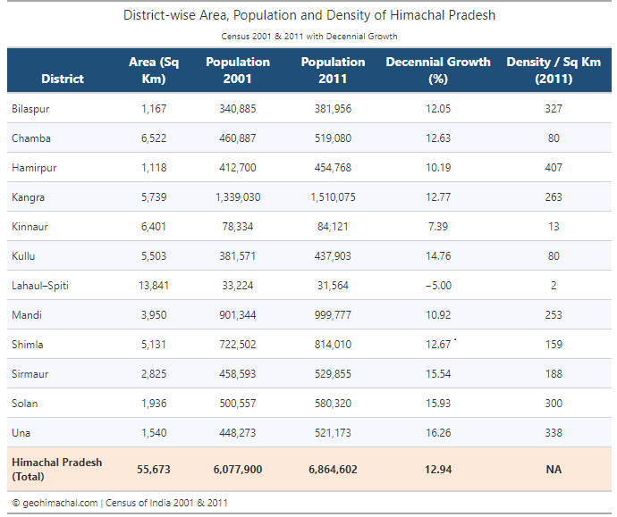
- Which district of Himachal Pradesh has the highest population density according to the 2011 Census?
a) Hamirpur
b) Bilaspur
c) Una
d) Kangra
Answer: a) Hamirpur - What is the population growth rate of Lahaul-Spiti between 2001–2011?
a) 5%
b) -5%
c) 0%
d) 10%
Answer: b) -5% - Which district recorded the highest decennial population growth rate (2001–2011)?
a) Solan
b) Una
c) Sirmaur
d) Kullu
Answer: b) Una - What is the total population of Himachal Pradesh according to the 2011 Census?
a) 60,77,900
b) 68,64,602
c) 55,67,300
d) 65,00,000
Answer: b) 68,64,602 - Which district has the lowest population density?
a) Lahaul-Spiti
b) Kinnaur
c) Chamba
d) Kullu
Answer: a) Lahaul-Spiti - Area of Kangra district in square kilometres is:
a) 6,522
b) 5,739
c) 3,950
d) 1,540
Answer: b) 5,739 - Which district had a population of 4,37,903 in 2011?
a) Bilaspur
b) Hamirpur
c) Kullu
d) Solan
Answer: c) Kullu - Which district has the maximum area?
a) Chamba
b) Kinnaur
c) Lahaul-Spiti
d) Kangra
Answer: c) Lahaul-Spiti - What is the population density of Shimla district according to 2011 Census?
a) 159
b) 188
c) 300
d) 263
Answer: a) 159 - Which district’s population grew by 15.93% between 2001–2011?
a) Solan
b) Sirmaur
c) Una
d) Kangra
Answer: a) Solan - What is the population density of Kinnaur district?
a) 13
b) 80
c) 2
d) 159
Answer: a) 13 - What was the population of Mandi district in 2001?
a) 9,99,777
b) 9,01,344
c) 8,14,010
d) 4,58,593
Answer: b) 9,01,344 - Which district had a decennial growth of 12.63%?
a) Chamba
b) Bilaspur
c) Shimla
d) Kangra
Answer: a) Chamba - Total area of Himachal Pradesh is:
a) 55,673 sq. km
b) 60,779 sq. km
c) 68,646 sq. km
d) 50,500 sq. km
Answer: a) 55,673 sq. km - Which district has a population density of 80?
a) Chamba and Kullu
b) Lahaul-Spiti and Kinnaur
c) Solan and Hamirpur
d) Una and Bilaspur
Answer: a) Chamba and Kullu - What is the population of Una district according to 2011 Census?
a) 4,48,273
b) 5,21,173
c) 5,29,855
d) 4,54,768
Answer: b) 5,21,173 - Which district has the smallest area?
a) Hamirpur
b) Una
c) Bilaspur
d) Solan
Answer: a) Hamirpur - Which district’s decennial growth was 7.39%?
a) Kinnaur
b) Mandi
c) Bilaspur
d) Shimla
Answer: a) Kinnaur - Which district had a population of 5,19,080 in 2011?
a) Chamba
b) Sirmaur
c) Una
d) Solan
Answer: a) Chamba - What is the average population density of Himachal Pradesh as per 2011 Census?
a) 123
b) 159
c) 188
d) 300
Answer: a) 123
Source:- Himachal Pradesh Geography Through Maps by Pardeep Kumar.
(Amazon buying link , Buy Now )