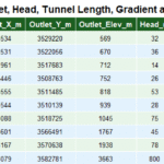
Technical Note: The Satluj River catchment in Himachal Pradesh covers 20000 sq km, calculated from SRTM 30 m DEM in QGIS 3.40.5 and validated with Survey of India and GSI data.
Origin of Satluj.
The Satluj originates near Lake Rakshastal in Tibet, close to Mount Kailash, at an altitude of about 4,575 meters. In Tibet it flow under the name of “Langzen Zangbu” for approximately 260 km before entering India through Shipki La Gorge.
Antecedent Nature of Satluj River
Satluj is a Trans-Himalayan Antecedent River, which mean it exist before the Himalayan origin and keep maintaining its southward course by cutting through evolving mountain thereby forming Deep Gorges and narrow valleys. Polycyclic Terrace on both bank of river further explained the phased evolution of Himalaya and continuous down cutting by river.
Gradient of Satluj River
Satluj after originating at height of 4575 Mt, flow swiftly in its initial course , river gradient fall at 6.82 mt/Km in upper most course. At Shipki la river flows at altitude of roughly 2800 Mt. On its journey from Shipki la to Rampur Bushar, gradient of river is roughly 10 mt/Km.
- After crossing the Rampur, gradient of river drop. Due to construction of numerous Dam , Satluj has become very muddy and river is biologically dead in most of its part. Pakshilamur Glacier,Kamen Galmo,Sumto ,Goma, Chango,Chorgas,Baspa,Racho, and Zangsu etc are important Glaciers of Satluj catchment.
Gradient Map of Satluj river in Himachal Pradesh.

copyright-geohimachal.com
copyright-geohimachal.com
Hydrology and Topology of Satluj river system
Once Satluj entered the India its Hydrology and Topology change significantly. Canyon are replaced with Gorges. Further in addition to Glacier fed streams many monsoonal streams also join the river, which increase over all sedimentation load of river. Sedimentation load further increase due to change in climatic regime and human induced activities.
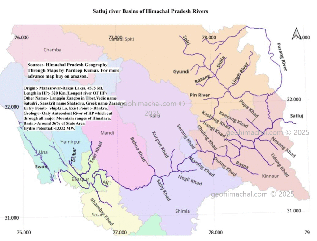
Tributaries of Satluj river
Spiti River
River Spiti is major tributary of Satluj, total catchment area of Spiti (Indian Territory) is approximately 574 Sq Km it is fed by perennial glacier of Greater Himalaya, it is perfect example of Longitudinal Consequent stream ,following the northern axis of Greater Himalayan range. River Spiti originates near Kunzum La. In fact Kunzum La range separate the Chandrabhaga basin from Satluj basin. The Spiti River has carved out a broad valley with steep cliffs and river terraces, showcasing fluvial and glacial geomorphology.
The Satluj river upper region is rich in fossils, particularly of marine origin.The river’s erosion activity contributes to the sediment load of the Satluj river downstream,Spiti join the Satluj at Khab.
Parang Stream
Among the all tributaries, Parang stream is worth mentioning here, Parang river originate in Kibber Valley, flow northward in Tibet for 110 Km and than take southern turn and join Satluj near Indo-Tibet border. It is a good example of a obsequent stream.
Seer Khad
It drained the part of Mandi, Hamirpur and Bilaspur is among the most important tributaries of Satluj. It is in the catchment of this river, many stones tools have been discovered. Seer Khad originate on the border of Mandi and Hamirpur, joined by Sukar and Saryali khads, powers water mills, flows deep, and becomes unfordable during rains.
Ali Stream
Originating in Solan, it flows 35 km through Bilaspur to join the Satluj at Beri Ghat; a perennial but rain-fed stream, low in summer and torrential in monsoon, once crossed using inflated animal skins.
Ghamber Khad
Rising in the Shimla hills, it joins the Satluj near Nerli after 13 km in Bilaspur; deep-bedded, flood-prone in monsoon, supports sport fishing, and crosses the Bilaspur–Nalagarh road.
Swan River
River Swan which drained the district Una is the major tributary of Satluj in Shivalik hills. In Fact Swan is largest river of Shivalik hills in Himachal Pradesh.
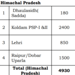
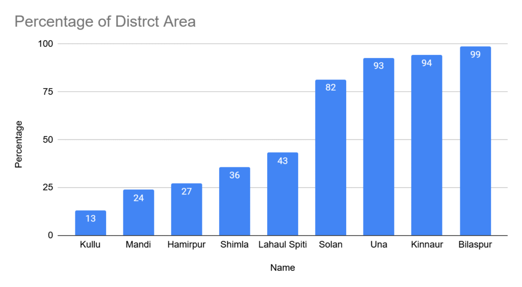
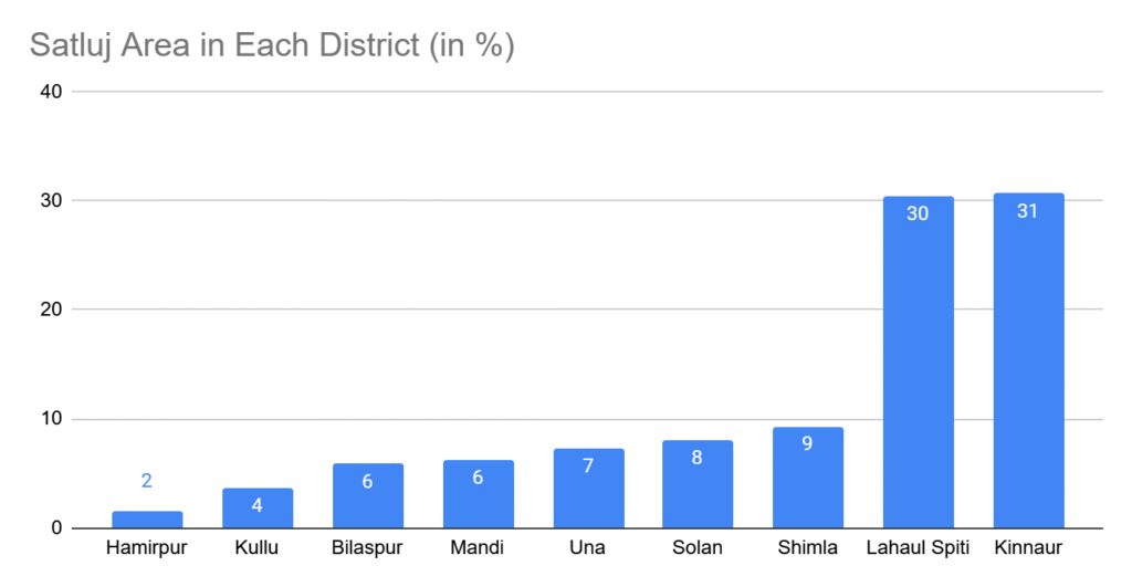
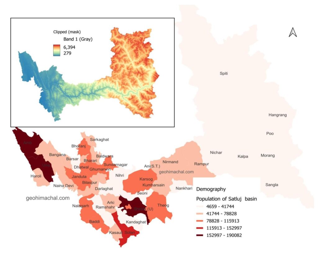
Satluj Catchment area in Different District of Himachal Pradesh
Total Catchment area of Satluj is around 20000 Km2 which fall with 9 district of Himachal Pradesh. Area wise Kinnaur(6135 km2) is the largest sub basin of Satluj followed by Lahaul Spiti (5907 km2) . However Bilaspur is the only district whose entire areas fall in catchment of Satluj , followed by Kinnaur(95.8%) ,Una(93%) and Solan (82%). Almost all area of Kinnaur expect few pockets fall in catchment of Bhagirathi.
copyright-geohimachl.com
Spiti Division of District Lahaul Spiti also fall in Satluj catchment it constitute around 30% of Satluj catchment area,nearly equal to Kinnaur 43 % area of District. Around 24 % area of Mandi , 27% area of Hamirpur and 36 % area of Shimla is Drained by Satluj.
copyright-geohimachal.com
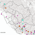
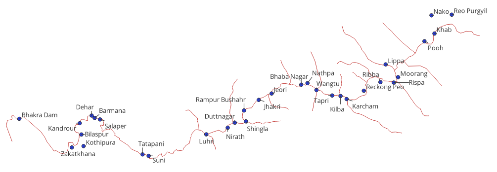
Human Settlement Across the Satluj:-
copyright-geohimachal.com
From above given map you can see that in initial course of Satluj there is very scanty population specially in district Kinnaur. It passes through Poo, Morang, Kalpa, Nichar. Onnce it enter the Shimla Population start to increase. Rampur, NIrmand, Karsog , Kumarsain, Seoni ,Nihri are important settlment. In its mid course perhaps Karsog is the largest settlement in term of Population.
Important Settlements
Along the rivers are Poo, Kalpa, Nichar, Nirmand, Rampur, Sunhi, Lippa, Morrange, Lurhi Jeori ,Bilaspur and Mehatpur. Tatapani , Suni etc.
copyright-geohimachal.com