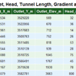
Technical Note: The Beas River catchment in Himachal Pradesh covers1404 sq km, calculated from SRTM 30 m DEM in QGIS 3.40 and validated with Survey of India and GSI data.
Beas originate near Rohtang pass at altitude of 4360 Mt in Pir Panjal range, however the stream which formed the main channel originate north of Solang valley where a mountain crest separate the Beas drainage basin from Ravi basin. Total catchment area of Beas is 1404 km2. Out of total catchment area 34 % fall in district Kullu, 19 % Mandi and 36.% in Kangra , 6 %in Hamirpur , 3 % in Chamba and 1% in Una.

Origin of Beas
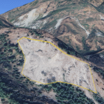
Beas is a consequent stream following the regional slope, in its upper course it form U shaped valley , however near Aut (Mandi and Kullu border) where it cut through the Dhauladhar range ,U shaped valleys replaced with deep Gorge i.e Larji Gorge.
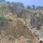
Larji Gorges Beas
Formation of Gorge is attributed to erosion capacity of river. Height of Larji gorge is approximately is 2050 Mtr, Beas flow through deep Gorge for roughly for 15 Km.
Existence of Larji Gorge proved that Beas is Antecedent to Dhauladhar. The rise of Dhauladhar range must have contributed to formation of vast temporary lake in Kullu valley.Further it is also believed that once Beas used to flow through Balh valley and was a major tributary of river Satluj. Present day plains of Balh valley are also attributed to sedimentation of Beas.
Gradient of Beas River
In its upper course it is a small stream with steep gradient roughly at 40 mt/kmSlope is calculated between Solang and Aut.. In its lower course river gradient is very gentle, roughly at 3.75 mtr/kmSlope is calculated between Aut and Pong Dam. as result interlocking spur and meandering path can be seen across its course.

Diagram of Larji Gorge Formed by Beas.
Diagram of Larji Gorge: After descending rapidly from its point of origin, river Beas form U shaped valley in Kullu, U shaped valley begin to replace with Deep Gorges near Larji, at the point where Beas cut through the Dhauladhar range. Largi Gorge is approximately 15 km long with average height 2050 mt( Difference between River Elevation and side Peaks)

River Course of Beas and Land forms.
Beas enter the district Kangra at Sandhol. In Kangra deep “V” shaped valleys and Gorges are replaced with open valley and river become very wide. Numerous tributaries rising from southern slope of Dhauladhar join the beas at right angle.
Landforms of Beas river
Beas tributaries that rise from Dhauladhar has polycyclic terrace along the course, indicating many cycle of erosion and deposition. Numerous granite moraine brought down by these rivers during ice age can be seen across the river course. Paror anticline(Garhwali Dhar) (Upper Shiwalik) divided the Kangra drainage basin in two parts, one part tilted toward east and other part tilted toward west.
Beas River Tributories
In district Hamirpur most important tributary of Beas is Kunah Khad, Man Khad, Pung Khad, Janglehar and Buar Khad. District headquarter is drained by Kunah Khad. Bakar Khad fomed the boundary with district Mandi.
In Una Chintpurni Dhar separate the Swan river basin (a Satluj Sub Basin) from Beas basin. Bhaitiyat area of District Chamba also drained by Beas. Infect Dhauladhar mountain separate the Ravi basin from Beas basin.Around 89 % area of Kangra, 87 % area of Kullu, 69 % area of Mandi, 73 % area of Hamirpur ,9 % area of Chamba and 5% area of Una is drained by Beas.
Beas River and Biodiversity
Water scape of Beas river is very rich in culture from ancient temple to monastery. From High mountain to fertile plains of Kangra all drained by Beas. Greater Himalayan National Park and Dhauladhar wildlife sanctuaries are rich biodiversity hotspots of region.