Read Full Study here https://doi.org/10.6084/m9.figshare.34735122
1. Introduction
In India the district is the main unit through which the state reaches its citizens. Land records, magisterial and court functions, disaster management, and the line departments of health, education and public works are all coordinated from the district headquarters. The time and cost of reaching that headquarters is therefore a direct measure of how accessible government is.
In a mountain state the straight-line map understates this cost. Ridges, gorges and river crossings force roads into long detours, and high passes close in winter. Two places a short distance apart on the map can be several hours apart by road. Questions of district size and boundaries in such terrain should be argued from road networks, not from area or straight-line distance.
Himachal Pradesh has had twelve districts since 1972, while its road network, settlement pattern and population have changed considerably. Proposals for new districts recur in public debate, but they are rarely backed by a consistent, state-wide measure of accessibility.
This study provides such a measure. It asks three questions:
- How far, by road and in travel time, is each tehsil from its own district headquarters?
- Which tehsils are nearer to another district’s headquarters, and by how much?
- Where does remoteness persist even when every existing headquarters is considered, indicating a case for new headquarters rather than boundary change?
2. Study area and data
Himachal Pradesh covers about 55,700 km² of the western Himalaya, from the Siwalik foothills along the Punjab border to the trans-Himalayan valleys of Lahul, Spiti and upper Kinnaur. It is divided into 12 districts and, in the boundary data used here, 123 tehsils and sub-tehsils. District size varies widely: Kangra has 22 tehsils and Lahul and Spiti only 3.
| Dataset | Content | Source |
|---|---|---|
| Tehsil boundaries | 123 polygons with LGD and Census 2011 codes | Local Government Directory (LGD) |
| District headquarters | 12 point locations | Compiled by the author |
| District boundaries | 12 polygons, reference only | LGD |
| Road network | All drivable roads | OpenStreetMap |
| Routing engine | Shortest car routes and times | OSRM, public server |
All spatial layers were projected to WGS 84 / UTM zone 43N (EPSG:32643) for area and straight-line measurement.
3. Methodology
The analysis proceeds in three steps.
3.1 Origin points. Each tehsil is represented by one point generated with st_point_on_surface() in the R package sf (Pebesma, 2018). Unlike a centroid, this point always lies inside the polygon, which matters for the irregular, elongated shapes of mountain tehsils. The administrative rationale is territorial: the district serves the whole tehsil area, including forest, pasture and hazard zones, not only its main town.
3.2 Network routing. Origins and the 12 headquarters were routed with the Open Source Routing Machine (OSRM; Luxen and Vetter, 2011) using its car profile over the complete OpenStreetMap road network. OSRM snaps each point to the nearest drivable road and returns the fastest route. For every tehsil this produced a 123 × 12 matrix of road distances (km) and travel times (minutes).
A first version of the analysis routed over a reduced road layer containing only National Highways, State Highways and district roads. Without village and link roads, some tehsils were forced onto long detours: Chachyot (Mandi) was given 209 km to Mandi, against 40.5 km on the full network. That version was discarded, and all results here use the full network.
3.3 Indicators.
| Indicator | Definition |
|---|---|
| Own-HQ distance and time | Road km and car minutes to the tehsil’s own district headquarters |
| Nearest HQ | Headquarters of any district with the shortest road distance |
| Nearest-HQ distance and time | Road km and car minutes to that headquarters |
| Saving | Own-HQ distance minus nearest-HQ distance |
| Nearer to another HQ | Yes where the nearest headquarters belongs to another district |
| Effective speed | Own-HQ distance ÷ travel time; a proxy for road quality and terrain |
A saving of 20 km or more is treated as material for boundary review; smaller savings are within the uncertainty of the origin point.
4. Results
4.1 Accessibility to own district headquarters
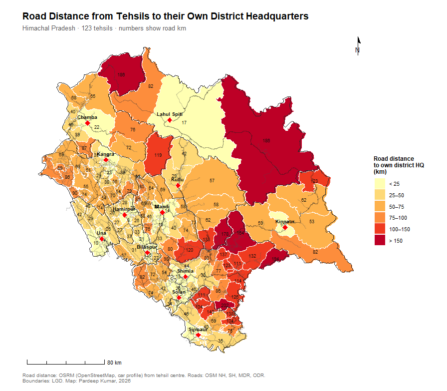
The median tehsil is 57.3 km (mean 64.4 km) and 79 minutes (mean 90 minutes) from its own headquarters. Seventy-one tehsils are more than 50 km away, 21 more than 100 km and 6 more than 150 km. By time, 26 tehsils are more than two hours away and 12 more than three hours.The contrast between districts is sharp (Figure 1). Hamirpur, Una and Bilaspur keep every tehsil within 60 km and one hour. Shimla has the highest mean (99.2 km) and the farthest tehsil (Bagachnogi, 201.6 km), so its problem is broad rather than a single outlier. Chamba and Lahul and Spiti have the longest journeys in time: Pangi takes 7.0 hours to Chamba and Spiti 7.9 hours to Keylong.
4.2 Travel time and road speed
Distance alone hides large differences in road quality. The median effective speed is 43.8 km/h, but it ranges from about 24 km/h on the hill roads of Chamba (Bharmour, Bhattiyat, Holi) and Spiti to over 70 km/h on the national highway corridors of Manali, Baddi and Hangrang. The twelve tehsils more than three hours from their headquarters are Spiti, Pangi, Rampur, Multhan, Dodra Kwar, Bagachnogi, Nirmand, Nankhari, Sihunta, Nohra, Bharmour and Udaipur.
4.3 Remote from every headquarters
Sixteen tehsils are more than 100 km from the nearest headquarters of any district (Table 1). For these, transferring the tehsil to a neighbouring district would not bring it within 100 km.
Table 1. Tehsils more than 100 km from every district headquarters
| Tehsil | District | Nearest HQ | Road km | Hours |
|---|---|---|---|---|
| Dodra Kwar | Shimla | Shimla | 194.4 | 3.7 |
| Spiti | Lahul and Spiti | Keylong | 185.6 | 7.9 |
| Nankhari | Shimla | Shimla | 137.0 | 3.5 |
| Pangi | Chamba | Keylong | 135.5 | 7.2 |
| Bagachnogi | Shimla | Solan | 135.4 | 3.6 |
| Ronhat | Sirmaur | Solan | 133.9 | 3.1 |
| Chirgaon | Shimla | Shimla | 131.6 | 2.1 |
| Nirmand | Kullu | Reckong Peo | 130.0 | 3.3 |
| Nerwa | Shimla | Shimla | 125.6 | 2.0 |
| Hangrang | Kinnaur | Reckong Peo | 123.2 | 1.6 |
| Tikar | Shimla | Shimla | 122.7 | 2.0 |
| Ani | Kullu | Shimla | 121.2 | 3.0 |
| Jubbal | Shimla | Shimla | 113.5 | 1.8 |
| Rohru | Shimla | Shimla | 111.4 | 1.7 |
| Shalai | Sirmaur | Sirmaur | 103.9 | 1.9 |
| Karsog | Mandi | Shimla | 103.1 | 2.2 |
Eight of the sixteen are in Shimla district, and seven of those (Chirgaon, Dodra Kwar, Jubbal, Nankhari, Nerwa, Rohru, Tikar) have no nearer alternative than Shimla itself.
4.4 Tehsils nearer to another district’s headquarters
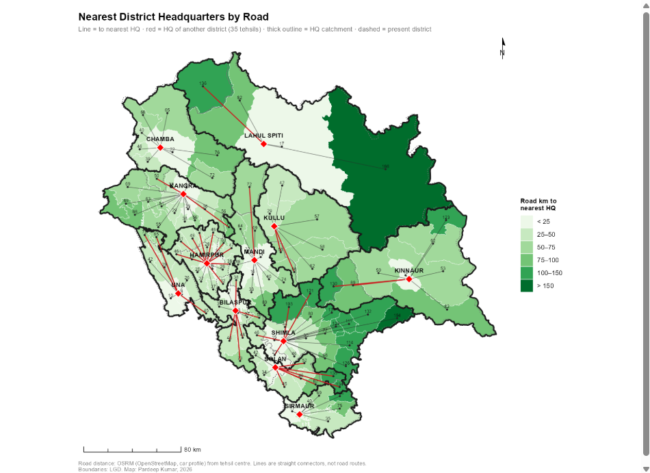
Thirty-five tehsils (28%) are nearer by road to another district’s headquarters. For 18 the saving is 20 km or more (Table 2).
Table 2. Tehsils nearer to another district HQ by 20 km or more
| Tehsil | Present district | Nearer HQ | Own HQ km | Nearer HQ km | Saving km |
|---|---|---|---|---|---|
| Rampur | Shimla | Kinnaur | 164.5 | 88.6 | 75.9 |
| Bagachnogi | Shimla | Solan | 201.6 | 135.4 | 66.2 |
| Rajgarh | Sirmaur | Solan | 104.4 | 46.2 | 58.2 |
| Haripurdhar | Sirmaur | Solan | 110.6 | 52.4 | 58.2 |
| Nohra | Sirmaur | Solan | 140.1 | 82.0 | 58.1 |
| Pangi | Chamba | Lahul and Spiti | 185.9 | 135.5 | 50.4 |
| Nirmand | Kullu | Kinnaur | 178.0 | 130.0 | 48.0 |
| Darlaghat | Solan | Bilaspur | 97.5 | 50.1 | 47.4 |
| Multhan | Kangra | Mandi | 118.6 | 72.4 | 46.2 |
| Nalagarh | Solan | Bilaspur | 91.6 | 46.0 | 45.6 |
| Baldwara | Mandi | Bilaspur | 75.7 | 37.8 | 37.9 |
| Sihunta | Chamba | Kangra | 86.9 | 50.3 | 36.6 |
| Jaisinghpur | Kangra | Hamirpur | 78.6 | 45.5 | 33.1 |
| Rakkar | Kangra | Hamirpur | 74.3 | 46.5 | 27.8 |
| Sandhol | Mandi | Hamirpur | 84.9 | 59.6 | 25.3 |
| Ramshahr | Solan | Bilaspur | 71.7 | 48.4 | 23.3 |
| Sarkaghat | Mandi | Hamirpur | 58.5 | 37.5 | 21.0 |
| Khundian | Kangra | Hamirpur | 69.6 | 49.4 | 20.2 |
Among the 25 tehsils with a saving of 10 km or more, Kangra (7) and Mandi (5) lose the most, while Hamirpur (8), Bilaspur (4) and Solan (4) are the most frequent alternative headquarters. In three cases the nearer headquarters by distance is slower by time (Pangi, Ani and Ronhat), because the shorter route uses lower-grade roads.
5. Discussion
5.1 Two distinct problems
The results show two different kinds of poor access, which call for different remedies.
Boundary mismatch occurs where a tehsil is reasonably close to a headquarters, but not its own. It is concentrated in the lower and middle hills: the Kangra–Hamirpur fringe (Jaisinghpur, Rakkar, Khundian), the Mandi–Hamirpur fringe (Sandhol, Sarkaghat), and the Solan–Bilaspur belt (Nalagarh, Ramshahr, Darlaghat). Here Hamirpur and Bilaspur, compact districts with short internal distances, have spare reach. The remedy is boundary adjustment, not a new district.
Structural remoteness occurs where a tehsil is far from every headquarters. It is concentrated in the high hills, and moving boundaries cannot solve it. Four clusters emerge:
- Upper Shimla: Chirgaon, Dodra Kwar, Jubbal, Nerwa, Rohru, Tikar and Nankhari, 111–194 km from Shimla with no nearer alternative.
- Sutlej valley: Rampur, Nirmand and Ani, split between Shimla and Kullu districts and 133–178 km from their present headquarters. Rampur and Nirmand are both nearer to Reckong Peo.
- Trans-Giri Sirmaur: Nohra, Haripurdhar, Rajgarh, Ronhat and Shalai, 104–140 km from Nahan, which lies at the southern edge of its district. Three of them are much nearer to Solan.
- Tribal north: Spiti and Pangi, the most remote tehsils in the state by time (7–8 hours), but with small, seasonal populations.
5.2 Implications for reorganisation
The first three clusters are the strongest spatial candidates for new district headquarters, because no existing centre serves them within 100 km or two hours. Upper Shimla and the Sutlej valley are the clearest: each forms a contiguous group of tehsils with a natural central town on the main road (Rohru and Rampur respectively). Trans-Giri Sirmaur could be served either by a new headquarters or by partial transfer to Solan.
The tribal north presents a different case. Its remoteness is extreme, but its low population suggests strengthening sub-divisional administration and winter-access arrangements rather than creating full districts.
5.3 Distance versus time
Travel time adds information that distance alone misses. Hangrang is 123 km from Reckong Peo but reachable in 94 minutes on the national highway, whereas Sihunta, only 87 km from Chamba, takes 201 minutes on hill roads. Any formal criterion for district size in mountain areas should therefore be expressed in hours, not kilometres.
6. Limitations and future work
- Origin point. Each tehsil is represented by an interior point rather than its headquarters town or population centre. In large tehsils this point may lie on a ridge or in forest, lengthening or redirecting the route. Bagachnogi’s 201.6 km, the highest value in the state, should be checked against its tehsil town.
- Network completeness. Results depend on the roads mapped in OpenStreetMap. Missing or mis-tagged village roads can still lengthen some routes, as the first version of this analysis showed.
- Travel time. OSRM uses standard car speeds by road class and does not model gradient, road condition, landslides or traffic. Real hill travel times are usually longer.
- Season. All roads are treated as open year-round. Winter closure of high passes (Rohtang, Kunzum, Jalori, Sach) would sharply increase travel times for Lahul, Spiti, Pangi and parts of Kullu and Shimla.
- Population. Every tehsil is weighted equally. A sparsely populated tehsil counts as much as a dense one.
Future work will (a) replace interior points with tehsil headquarters towns; (b) weight tehsils by Census and electoral-roll population; (c) model winter closures using a DEM elevation cut-off; (d) test candidate headquarters with a p-median location–allocation model (Hakimi, 1964); and (e) check proposed boundaries against Assembly Constituencies.
7. Conclusion
Road-network routing over open data gives a consistent, state-wide picture of how far Himachal Pradesh’s tehsils are from district administration. One tehsil in six is more than 100 km from its headquarters, and one in ten is more than three hours away. The problem is not evenly spread: it is concentrated in a few high-hill belts, while the lower-hill districts are compact.
The analysis separates where boundary adjustment is enough (35 tehsils nearer to another headquarters, mainly around Hamirpur, Bilaspur and Solan) from where only new headquarters can help (16 tehsils beyond 100 km of every headquarters, mainly in upper Shimla, the Sutlej valley and trans-Giri Sirmaur). These results are a screening layer. Combined with population, seasonal access and constituency boundaries, they can support an evidence-based proposal for district reorganisation.
References
- Hakimi, S. L. (1964). Optimum locations of switching centers and the absolute centers and medians of a graph. Operations Research, 12(3), 450–459.
- Luxen, D., & Vetter, C. (2011). Real-time routing with OpenStreetMap data. Proceedings of the 19th ACM SIGSPATIAL International Conference on Advances in Geographic Information Systems, 513–516.
- OpenStreetMap contributors. OpenStreetMap road network for India, accessed October 2026.
- Pebesma, E. (2018). Simple Features for R: Standardized support for spatial vector data. The R Journal, 10(1), 439–446.
- Ministry of Panchayati Raj, Government of India. Local Government Directory (LGD): sub-district boundaries.