New Districts in Himachal Pradesh: Distance Findings
Oct 17, 2026 .
Key findings
A typical tehsil is 56 km by road from its district HQ, but 23 of 123 tehsils are more than 100 km away, and 34 tehsils are nearer to another district’s HQ than to their own.
- Remoteness is concentrated, not spread. All 15 tehsils beyond 120 km lie in four belts: upper Shimla, the Sutlej valley (Rampur–Nirmand–Ani), Seraj in Mandi, and the tribal north (Spiti, Pangi).
- Two clusters have no better HQ nearby. Upper Shimla (Chirgaon, Dodra Kwar, Nerwa, Tikar, Jubbal, Rohru) and trans-Giri Sirmaur (Ronhat, Shalai) are far from every existing HQ. Moving boundaries cannot fix them; only a new HQ can.
- The Sutlej valley is split across districts. Rampur (Shimla) and Nirmand (Kullu) are 158 and 182 km from their own HQs and would save 71 and 54 km at Reckong Peo. Together with Ani, Kumarsain and Nankhari they form a cross-district cluster around Rampur.
- Lower-hill edges point to boundary changes. Mandi (10), Kangra (8) and Solan (5) lose most tehsils to neighbouring HQs, mostly Hamirpur, Una and Bilaspur. Here the remedy is transfer, not a new district.
- Seraj has the highest detours in the state. Chachyot, Thunag and Bali Chowki show 170–210 km to Mandi against 20–34 km by air (detour up to 10.5). Their remoteness comes from terrain and road alignment, not distance on the map.
What was measured
Each of the 123 tehsils was given one interior point, linked to the nearest NH/SH/MDR/ODR road, and routed along roads to all 12 district HQs (R: sf, dodgr; 13,292 km of OSM roads).
| Indicator | Meaning |
|---|---|
| Total km | Road distance from tehsil to its own district HQ, including the off-road gap |
| Air km | Straight-line distance to own HQ |
| Detour | Road km ÷ air km; a proxy for terrain and road circuity |
| Nearest HQ | The district HQ that is closest by road, from any district |
| Saving km | Own-HQ distance minus nearest-HQ distance |
This is a screening stage: distance only. Population, travel time and winter closures are not yet included.
Statewide picture
The problem sits in the big hill districts: Mandi, Lahul and Spiti, Chamba, Kullu and Shimla each have a tehsil over 150 km from HQ, while Hamirpur, Una and Bilaspur keep every tehsil within 60 km.
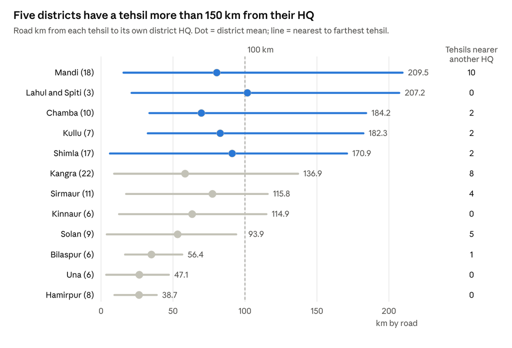
Tehsil_to_DHQ_Distance_Report.pdf, Table 4 · 123 tehsils, 12 districts · tehsil counts in brackets
Shimla has the highest mean (91 km) with 17 tehsils, so its reach problem is broad, not one outlier. Mandi and Kangra lose the most tehsils to neighbouring HQs (10 and 8), which points to boundary review rather than distance alone.
Remote tehsils (over 100 km)
23 tehsils are more than 100 km from their own HQ; 10 of them are already at their nearest HQ, so no transfer would bring them closer.
| Tehsil | District | Km to own HQ | Nearest HQ | Saving km | Belt |
|---|---|---|---|---|---|
| Chachyot | Mandi | 209.5 | Shimla | 9.8 | Seraj |
| Spiti | Lahul and Spiti | 207.2 | Lahul and Spiti | 0 | Tribal north |
| Bali Chowki | Mandi | 188.2 | Shimla | 9.9 | Seraj |
| Pangi | Chamba | 184.2 | Lahul and Spiti | 56.7 | Tribal north |
| Nirmand | Kullu | 182.3 | Kinnaur | 53.7 | Sutlej valley |
| Thunag | Mandi | 172.9 | Shimla | 9.9 | Seraj |
| Bagachnogi | Shimla | 170.9 | Solan | 36.0 | Sutlej valley |
| Rampur | Shimla | 158.6 | Kinnaur | 71.1 | Sutlej valley |
| Dodra Kwar | Shimla | 144.9 | Shimla | 0 | Upper Shimla |
| Chirgaon | Shimla | 137.5 | Shimla | 0 | Upper Shimla |
| Multhan | Kangra | 136.9 | Mandi | 46.3 | Bara Bhangal |
| Ani | Kullu | 133.6 | Shimla | 1.8 | Sutlej valley |
| Nerwa | Shimla | 125.7 | Shimla | 0 | Upper Shimla |
| Tikar | Shimla | 125.0 | Shimla | 0 | Upper Shimla |
| Karsog | Mandi | 120.9 | Shimla | 6.4 | Seraj |
| Nohra | Sirmaur | 115.8 | Solan | 31.0 | Trans-Giri |
| Hangrang | Kinnaur | 114.9 | Kinnaur | 0 | Tribal north |
| Ronhat | Sirmaur | 114.8 | Sirmaur | 0 | Trans-Giri |
| Jubbal | Shimla | 112.4 | Shimla | 0 | Upper Shimla |
| Haripurdhar | Sirmaur | 110.8 | Solan | 57.5 | Trans-Giri |
| Rohru | Shimla | 110.4 | Shimla | 0 | Upper Shimla |
| Rajgarh | Sirmaur | 104.7 | Solan | 57.5 | Trans-Giri |
| Shalai | Sirmaur | 100.6 | Sirmaur | 0 | Trans-Giri |
Shimla district alone holds 8 of the 23.
Tehsils better served by another HQ
34 tehsils are nearer to another district’s HQ, but only 16 would save 20 km or more; the other 18 save under 20 km and do not justify a change in distance alone.
| Tehsil | Now in | Nearer HQ | Own HQ km | Nearer HQ km | Saving km |
|---|---|---|---|---|---|
| Rampur | Shimla | Kinnaur | 158.6 | 87.5 | 71.1 |
| Rajgarh | Sirmaur | Solan | 104.7 | 47.2 | 57.5 |
| Haripurdhar | Sirmaur | Solan | 110.8 | 53.3 | 57.5 |
| Pangi | Chamba | Lahul and Spiti | 184.2 | 127.5 | 56.7 |
| Nirmand | Kullu | Kinnaur | 182.3 | 128.6 | 53.7 |
| Multhan | Kangra | Mandi | 136.9 | 90.6 | 46.3 |
| Sandhol | Mandi | Hamirpur | 95.3 | 50.0 | 45.3 |
| Nalagarh | Solan | Bilaspur | 93.9 | 51.5 | 42.4 |
| Darlaghat | Solan | Shimla | 86.4 | 50.3 | 36.1 |
| Bagachnogi | Shimla | Solan | 170.9 | 134.9 | 36.0 |
| Ramshahr | Solan | Bilaspur | 75.2 | 42.4 | 32.8 |
| Nohra | Sirmaur | Solan | 115.8 | 84.8 | 31.0 |
| Sarkaghat | Mandi | Hamirpur | 62.2 | 32.2 | 30.0 |
| Rakkar | Kangra | Hamirpur | 73.1 | 43.1 | 30.0 |
| Lad Bharol | Mandi | Kangra | 96.2 | 72.5 | 23.7 |
| Aut | Mandi | Kullu | 50.2 | 28.6 | 21.6 |
Three patterns stand out:
- Hamirpur pulls the lower hills. Sandhol, Sarkaghat and Dharmpur (Mandi) and Rakkar, Thural, Jawalamukhi, Khundian (Kangra) are all nearer Hamirpur. Hamirpur has the shortest distances in the state (max 38.7 km), so it has spare reach.
- Solan pulls northern Sirmaur. Rajgarh, Haripurdhar, Nohra and Pachhad are nearer Solan than Nahan, which sits at the southern edge of its district.
- Bilaspur pulls the Nalagarh–Baddi belt. Nalagarh, Ramshahr and Baddi are nearer Bilaspur than Solan town.
Two cases need care. Pangi’s shorter route to Keylong runs over high passes that close in winter, so the saving may vanish for months. Multhan’s centre is 20 km from any road (Bara Bhangal), so its result reflects where the road begins, not where people live.
Terrain signal (detour index)
The median road route is 2.0 times the straight-line distance; 17 tehsils exceed 3.0, and these mark where terrain, not distance, is the barrier.
Detour is only meaningful when the air distance is reasonably long. Tehsils next to their HQ (Bilaspur Sadar 6.1, Mandi 5.0, Shimla urban 5.0) score high only because the air distance is 1–6 km.
| Tehsil | District | Air km | Road km | Detour | Status |
|---|---|---|---|---|---|
| Chachyot | Mandi | 19.8 | 208.2 | 10.5 | Terrain barrier |
| Thunag | Mandi | 30.3 | 171.0 | 5.6 | Terrain barrier |
| Bali Chowki | Mandi | 34.3 | 185.1 | 5.4 | Terrain barrier |
| Dadahu | Sirmaur | 12.0 | 56.0 | 4.7 | Terrain barrier |
| Nohra | Sirmaur | 28.0 | 114.0 | 4.1 | Terrain barrier |
| Sunni | Shimla | 11.7 | 43.4 | 3.7 | Terrain barrier |
| Rajgarh | Sirmaur | 29.5 | 104.5 | 3.5 | Terrain barrier |
| Renuka | Sirmaur | 22.2 | 78.5 | 3.5 | Terrain barrier |
| Sandhol | Mandi | 29.0 | 94.1 | 3.2 | Terrain barrier |
Sirmaur stands out: four of its tehsils exceed 3.5, so Nahan is close on the map but far by road. This supports the case for a second HQ in northern Sirmaur.
Candidate zones for new districts
On distance alone, Upper Shimla and the Sutlej valley are the strongest cases; Seraj and northern Sirmaur follow, and the tribal north needs a different remedy.
| Zone | Tehsils | Area km² | Km to present HQ | Why it qualifies | Strength |
|---|---|---|---|---|---|
| Upper Shimla | Rohru, Chirgaon, Dodra Kwar, Jubbal, Tikar, Nerwa, Chaupal | 2,279 | 87–145 | All far from Shimla, and no other HQ is nearer | Strong |
| Sutlej valley | Rampur, Nirmand, Ani, Kumarsain, Nankhari, Bagachnogi | 2,101 | 81–182 | Far from Shimla and Kullu; split across two districts | Strong |
| Seraj–Karsog | Thunag, Bali Chowki, Chachyot, Karsog, Nihri | 1,590 | 73–210 | Far from Mandi; HQ alternatives only marginally nearer | Strong |
| Northern Sirmaur | Rajgarh, Haripurdhar, Nohra, Ronhat, Shalai | 807 | 101–116 | Far from Nahan, high detour; three are nearer Solan | Moderate |
| Tribal north | Spiti, Pangi | 8,763 | 184–207 | Most remote, but very small, seasonal population | Sub-division or ADM, not a district |
Kangra is a separate case. It has 22 tehsils, the most of any district, but its farthest tehsils (Fatehpur, Indora, Nurpur) are only 69–84 km away. Any split there would rest on administrative load and population, not distance.
A new HQ town for each zone has not been tested yet. Rohru and Rampur are the obvious towns to test first.
Data notes and limitations
The results were reviewed by the author and accepted for this screening stage; the points below bound how they should be read.
- Origin point. Each tehsil is represented by an interior point. In five large tehsils it lies far from any road (Udaipur 23.9 km, Multhan 20.0, Sangla 15.6, Bhuntar 13.2, Sainj 12.4), so their totals include a long off-road gap.
- Road network. Only NH, SH, MDR and ODR roads are included; village roads are absent and could shorten some routes.
- Distance, not time. Figures are road kilometres; speed, gradient and road condition are not modelled.
- Season. All roads are treated as open year-round. Pangi’s shorter route to Keylong crosses passes that close in winter.
- Single criterion. Population, administrative load, area and cost are not yet weighed.