Title
Preliminary Evidence for a Possible Monastic Complex within the Kangra Fort, District Kangra, Himachal Pradesh.
Author
Pardeep Kumar
Affiliation: Independent Researcher.
Full Article Available on : https://doi.org/10.5281/zenodo.19199968 ( This article submitted for Review to Ancient Asia )
Abstract
This paper presents a preliminary archaeological assessment of Kangra Fort in District Kangra, Himachal Pradesh. While the Fort is identified as an ancient Fort and is traditionally attributed to a Katoch lineage, surface observations reveal ancient architectural features inconsistent with purely defensive construction. Through field observation, spatial analysis using QGIS, and comparative layout study with known Buddhist monasteries of north-western India, this study suggests that a portion of the Fort may represent a secondary occupation built over an earlier Buddhist monastic complex (vihāras). The evidence is based on layout geometry, spatial repetition of cells, and courtyard-centric planning.
Keywords
Buddhist vihāra, Kangra fort, Shivalik foothills, fort reuse, Surface archaeology, Hindu Shahi, Katoch King , Kangra History.
Introduction
The Shivalik foothills of Himachal Pradesh form a transitional zone between the Indo-Gangetic plains and the mid-Himalayan cultural landscape. Kangra fort is located on the northernmost edge of Shivalik hills on the bank of Banganga in district Kangra, Kangra outwash plains separate the Kangra from Dhauladhar Mountain range. In ancient times the region was known as Trigarta, Nagarkot, Bhimnagar, Kangra and Sushampura.
The Proto-history of the region is traced back to Paleolithic age, Kangra and the surrounding region have yielded the stone age from lower Paleolithic age to upper Paleolithic age. Pāṇini’s Ashtadhyayi written in 5th Century BC was the first to mention Trigarta. Mahabharata and Purana mention Trigarta and surrounding republics frequently (Thakur 1997, 15; Vogel 1933, 105).
The region came under strong Buddhist influence from Mauryan period, Ashokan Kalsi’s rock inscription along the Himachal Pradesh and Uttarakhand border confirm Ashokan efforts to propagate Buddhist Dhamma. Local republicans like Adumabara, Kunninda’s and Trigarta’s coins show their allegiance toward Buddhism and Brahminism (Handa 2007). The discovery of ancient coins shows that the Kangra remain under the influence of Indo-Greek, Indo-Scythian and Kushana. The region also faced the onslaught of Huns invasion in mid of 6th century (Hāṇḍā 1994, 23–24) and Turkish invasion in 11th century.
Kangra fort located in such a Socio-Political landscape is renowned for its impregnability and vast wealth. The present study mapped the historical Kangra fort and proposed a probable Buddhist monastery complex inside the Kangra fort.
Methodology
The study employed a non-invasive and multi-disciplinary approach. Fieldwork consisted of repeated site visits, surface observation, and detailed photography of exposed architectural elements. No excavation or material removal was undertaken. Spatial analysis was carried out using QGIS. High-resolution satellite imagery was georeferenced, and visible wall alignments, courtyards, and structural boundaries were digitized to reconstruct the underlying plan and measurement and then this layout was compared with ground observation and existing available records. This reconstructed layout was then compared with published plans of known monasteries from north-western India. Comparative architectural analysis focused on layout geometry, room dimensions and site selection.
Regional and Historical Context
Kangra fort lies near the north-west region of India which links Central Asia with the rest of India. These corridors were active from early historic times and were frequently used by foreign invaders, traders, pilgrims, and religious communities. The discovery of ancient coins related to Adumbara, Kunnindas, Indo-Greeks, Indo-Scythian and Kushana as etc in Kangra and its adjoining regions show that region was politically and religiously active in ancient times(Handa 2007). In Ashokan times Thera Majjhima was sent to the Himalaya country, to spread Buddhism in the Himalayan region(Mahavamsa n.d., Chapter XII) .
Kangra district has yielded rich Buddhist artifacts from the second century before the common era onward. A 200 BCE bilingual Pathiyar rock inscription located in Pathiyar, Nagrota Bagwan roughly 15 km away from Kangra fort is the oldest historical record of any kind in the state. In 1854 , T. D. Forsyth discovered an idol of Buddhist Tantric Goddess Vajravarahi ,a lota and structural elements of the Temple from the adjoining villages to Pathiyar. A headless Buddha statue was also discovered from the same locality(Hāṇḍā 1994, 28).
Another group of bilingual inscriptions located in Khaniyara near Dharamshala roughly 10 Km ,in the North-west direction of Pathiyar is dated to 100 CE indicating the existence of Buddhist vihāra. The Chetru stupa located near Dharamshala is another significant site belonging to the early Gupta Period roughly dated 200-300 CE (Archaeological Survey of India 2002, 32).
From the 5th Century onward Vajrayana Buddhism became popular in the region. Many Buddhist deities such as Prajanmitra , Vajravahi and Varahi have been recovered from the adjoining region of Kangra (Hāṇḍā 1994). Further the account of Hiuen Tsang’s visit to the kingdom of Jalandhara (Trigarta) in 635 CE provides critical historical aspects for understanding the religious aspects of the Punjab and Himachal hills ,however there is no reference of Hiuen Tsang’s visit to present day Kangra.
From the 7th century onward, the rise of the Tantric traditions marked a transformative phase in Buddhism (Gray 2016), characterized by esoteric ritual practices and yogic experimentation. In Himalayan region during this period, parallel developments in Shaivism and Tantrism led to significant ritual and iconographic convergence, particularly in tantric symbolism and sacred space. As a result, several Buddhist tantric sites were gradually assimilated into evolving Hindu temple traditions, reflecting processes of syncretism rather than abrupt religious replacement (Hāṇḍā 1994, 40).
Historically, Kangra region formed part of the ancient kingdom of Trigarta, which encompassed the area between the Ravi, Beas, and Satluj rivers. The earliest references to Trigarta occur in Pāṇini’s Ashtadhyayi, the Mahabharata, and various Puranic texts. These sources describe it as a martial republic consisting of a confederation of six states (Vogel 1933).
Kalhana’s twelfth-century chronicle Rajatarangini records several early references to Trigarta. It notes that in the fifth century CE the Kashmiri ruler Pravarasena-I granted land in Trigarta to the deity Pravaresa (Shiva), while his successor Pravarasena-II later conquered the region in the early sixth century. Another account from the late ninth century mentions the Trigarta ruler Prithivi Chandra fleeing before the Kashmiri king Shankaravarman(Sir Aurel Stein 1892). These references confirm the antiquity of the Trigarta polity but relate mainly to the plains region and do not specifically mention Kangra.
The first clear historical reference to Kangra fort appears in the Persian chronicle Tarikh-i-Yamini, which describes the campaign of Mahmud of Ghazni in 1009 CE. The period between the eighth and tenth centuries was a critical phase in the history of north-western India. During this period the Hindu Shahi dynasty replaced the earlier Turk-Shahi rulers in the frontier regions and increasingly faced military pressure from the Ghaznavids. Numerous Hindu-Shahi coins have been discovered within Kangra fort. Some scholars, such as Abdur Rehman (1976) have suggested that the fort functioned as a treasury of the Hindu Shahi kingdom, which may have attracted the attack of Mahmud of Ghazni in 1009 CE. After this invasion, historical records begin to mention Kangra fort more frequently (Vogel 1933).
The present paper hypothesizes that the core section of Kangra Fort, based on its architectural layout and construction material, indicates the presence of an earlier Buddhist monastic complex.
Literature Review
The earliest historical references associated with Kangra and fort are indirect and emerge from regional historical chronicles rather than architectural descriptions of the Fort itself. Local accounts of Chamba and Kullu are also silent about Kangra, prior to the campaign of Mahmud of Ghazni in 1009 CE.
One of the earliest literary sources is the Rajatarangini, the 12th century Kashmiri chronicle composed by Kalhana. The chronicle records that around the 5th century CE the Kashmiri ruler Pravarasena I granted land in Trigarta to the deity Pravaresa (Siva), described as the protector of towns. Later references mention that his successor Pravarasena II conquered the territory of the Trigartas in the early 6th century, and another episode from the late 9th century describes Prithivi Chandra, the ruler of Trigarta, fleeing before the Kashmiri king Sankaravarman. These references indicate that the Trigarta region existed as a recognized political entity several centuries before the 10th century (Stein S 1900).
The first explicit historical reference to Kangra fort, historically known as Nagarkot, appears in Persian chronicles associated with the Ghaznavid invasions of northern India. The court historian Abu Nasr Muhammad al-Utbi, in his work Tarikh-i-Yamini (early 11th century), described the campaign of Mahmud of Ghazni against the fortress of Nagarkot in 1009 CE and recorded the vast temple wealth captured during the invasion. The contemporary scholar Al-Biruni also referred to Nagarkot in his work Kitab al-Hind (c. 1030 CE) while describing important regions and religious centers of India (Cunningham 1875; Ashvini Agrawal and C. Dorje 2016).
In medieval Persian chronicles of the Delhi Sultanate too, Kangra fort appears mainly in connection with military campaigns. Historians record that Firuz Shah Tughlaq captured the fort in 1360 CE during his expedition into the Himalayan foothills. Later, in the Mughal period, the region came under the authority of Emperor Akbar in the late sixteenth century, and Mughal records continued to describe Kangra as one of the strongest hill forts of northern India (Cunningham 1875; Ashvini Agrawal and C. Dorje 2016). However, these medieval accounts focus primarily on political events, military expeditions, and the wealth of the temples associated with the fort. They do not provide any detailed description of the architectural layout or internal structure of Kangra fort.
Later historical interpretations, particularly those of Alexander Cunningham, drew attention to an additional detail reported in the Persian narratives. According to Cunningham, a genealogical record of the Indo-Scythian rulers of Kabul, extending across sixty generations, was reportedly discovered within the fortress by Mahmud’s soldiers (Cunningham 1875).
Alexander Cunningham provides one of the earliest systematic descriptions of the internal layout of Kangra fort. He notes that the highest point of the fort is occupied by the palace complex, below which lies a courtyard containing small temples dedicated to Lakshmi Narayan and Ambika Devi, along with a Jain shrine housing a large image of Adinath. This arrangement indicates a spatial hierarchy in which the royal residence and sacred structures occupied the most elevated and protected part of the fort (Cunningham 1875). Apart from these descriptions we do not have any publicly available layout map of the fort.
In contrast, studies of Buddhist monastic architecture in northwestern India and Gandhāran provide a well-developed comparative framework. Archaeological research has demonstrated that early Buddhist monasteries typically followed a quadrangular plan, with monastic cells arranged around a central courtyard and enclosed within a bounded complex (Dharkar 2019; Fogelin 2015). In the Gandhāran region, these monasteries often exhibit fortified characteristics, including thick outer walls, controlled access points, and inward-oriented layouts.
Behrendt (2004) further refines this understanding by proposing a four-phase developmental model of Gandhāran monastic architecture, ranging from simple residential units to complex, ritualized institutions incorporating image shrines and structural modifications. This model highlights a broader pattern of architectural evolution, reuse, and transformation within monastic sites.
Within this broader scholarly context, the absence of architectural analysis for Kangra fort becomes particularly significant. The existing gap suggests that the internal layout of the fort has not been examined through an archaeological and architectural lens. The present study addresses this gap by applying a comparative framework derived from northwestern monastic traditions to interpret the spatial organization and structural features of the Kangra complex.
Site Description
The site is situated on gently elevated hills at an altitude of about 700 meter above sea level, overlooking the Banganga and Manjhi streams, both of which form part of the Beas river system. This elevated position provides extensive visibility over the surrounding landscape, a factor that may have influenced the initial selection of the location for settlement. In its present form the structure appears as a fort, characterized by thick boundary walls and localized bastion-like projections. However, the internal spatial arrangement of a portion of the fort does not fully correspond with typical defensive planning. Instead, it suggests multiple phases of occupation and reuse, where earlier structural elements may have been incorporated into later fortification works.
The core complex of Kangra fort can be broadly divided into four sections: eastern, western, central, and southern (Figure:1). Presently this core area alone is open for visitors and other parts of the fort are prohibited, however existing studies, online records and documentary show the presence of few Ponds, underground tunnels and gates in prohibited areas. The present study is focused on the core area where Temples, palaces and barracks are located; this part of the fort is accessed through only a single gate known as Darshani Darwaza.
The Darshini Darwaza on the northern side opens into a large courtyard, which today is flanked on two sides by barracks constructed during the British period. Slightly above this courtyard are the temples of Lakshmi Narayan and Sheetla Devi, occupying a raised platform within the complex.
A passage between the eastern and western sections leads toward the central section of the complex. The central section includes the palace zone, a corridor, and associated barracks. The palace complex occupies the highest point of the fort, located above the Lakshmi Narayan and Sheetla temples. In the southern section of the fort there is a well, along with additional barrack structures. The Proposed monastic complex is located on the Eastern side of the complex.
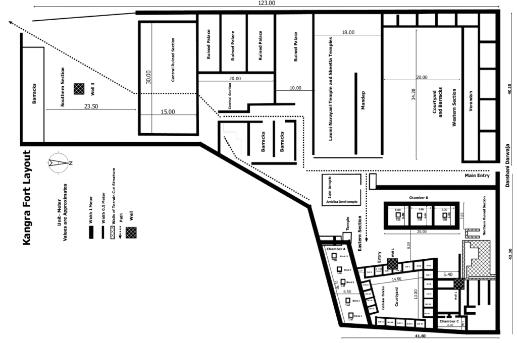
Figure-1: Layout Map Core section of Kangra fort.
Description of Architectural Components of the Eastern Section
The eastern section is located on a cliff toward Banganga river at 700 m elevation. It contains many sub-sections (Table:1, Figure: 2 & 2a), the most interesting is a group of 20 roughly equal-sized cells of 5 m², measuring 2.5 x 2 m and arranged around a courtyard of 14 x 13 m (Figure:3). The cells are arranged in quadrilateral formation around the courtyard. The door of each cell opened from the side wall and not from the centre. There are no windows in cells. All cells have similar size except minor variation to accommodate the uneven terrain.
The cells also have corbels to support the roof. The courtyard has a single entry point which is 1 m wide, although this entry is presently closed. The cells were constructed using locally available dressed and semi-dressed stone blocks. The masonry consists of irregularly sized stones arranged in roughly horizontal courses and bonded with lime mortar. The walls are thick and load-bearing.
Table -1 ( In meter ) , See : Figure-2
| Sr. No | Particular | Length | Width | Phases |
| 1. | Chamber A | 21.50 | 6.50 | Phase-1 |
| 2. | Chamber B | 20 | 7 | Phase-1 |
| 3. | Chamber C | 8 | 3 | Phase-1 |
| 4. | Court yard | 14 | 13 | Phase-1 |
| 5. | Cells | 2.5 | 2 | Phase-1 |
| 6. | Well | 4.50 | 2.50 | Phase -2 |
| 7. | Raised Platform Attached with Chamber-A | Not measured | Not measured | Phase-2 |
| 8. | Ambika Devi & Jain Temple Complex. | Not measured | Not measured | Phase-2 |
| 9. | Terrain cut Structure | Not measured | Not measured | Can not be assigned |
The floor of the cell is paved with large, roughly stone slabs. The heavy lime plaster must have been used to give a smoother look to the walls.
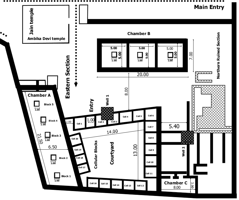
Figure-2: Layout map Eastern Section.
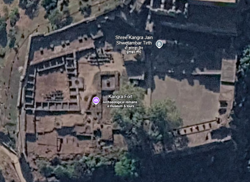
Figure-2a: Satellite view of Kangra fort (Google Earth 2026).
The southern side of the courtyard is attached to Chamber-A, a rectangular space measuring approximately 21.50 × 6.50 m (Figure:3). The chamber contains five structural stone blocks, each roughly 1 m³ in size, arranged along the central axis at intervals of about 5 m. Chamber-A is situated at a slightly higher elevation than the courtyard, indicating a deliberate spatial transition between the two areas or utilisation of slope of natural terrain. The internal space of the chamber is open and significantly larger than the adjoining cells, which suggest that it served a function different from the smaller residential units within the complex. A small raised platform is also found attached to Chamber-A at western side. At this same location four monolithic pillars are also attached.
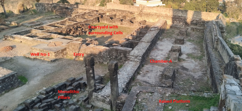
Figure-3 : Courtyard with surrounding 20 cells, Chamber-A, Well No-1 and closed entry.
The centrally aligned structural blocks appear intentionally positioned at intervals of 5 m and likely functioned as bases for vertical supports, possibly wooden pillars that carried a roof or superstructure. Although structural block no 4 has vanished , its base is still visible. The regular spacing and alignment indicate a planned architectural arrangement within the chamber.
Between the courtyard and the Ambika–Jain temple complex lies another Chamber-B of 20 x 7 m dimension divided into three equal sections (Figure:4) . Each of these sections have structural stone blocks similar in size and shape to structural blocks of Chamber-A.
On the northeastern side, the courtyard adjoins a smaller rectangular unit identified as Chamber-C measuring approximately 8 × 3 m (Figure:5). The wall facing the courtyard contains two openings. The wider opening on the left side, represents the doorway providing access to the chamber. Adjacent to it, on the right side, is a narrower opening positioned slightly higher in the wall, which likely functioned as a window.
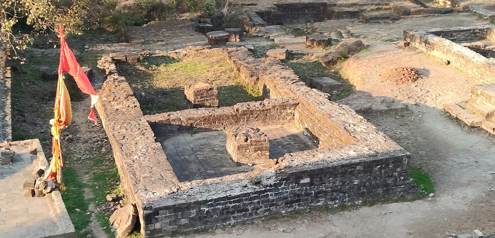
Figure- 4: Chamber- B.
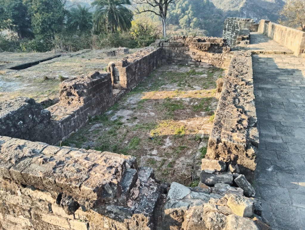
Figure-5 : Chamber- C.
There are also two wells in the eastern section. Well no-1 is constructed near the entry to the courtyard on cell no 2 & 3 and well no-2 is located in the Northern ruined section . In the Northern Ruined Section there is a Terrain cut structure having depth of approximately 2 m (Figure:6). Fragments of old structures such as large monolithic pillars and large blocks can be seen here.
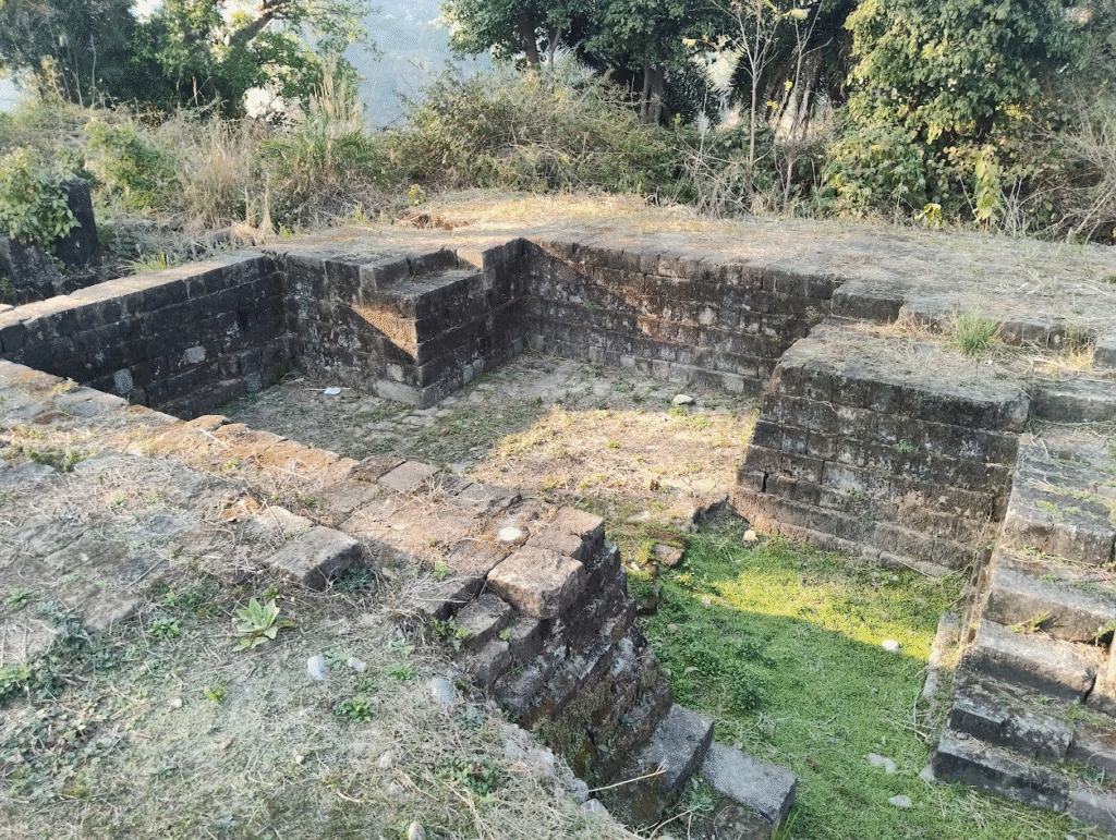
Figure-6 : Northern Ruined Section.
The Ambika–Jain temple complex is situated near the entrance of the site. The temple lacks a shikhara and instead features a low, nearly flat dome. It contains a garbhagriha that functions as a shared mandapa for both the Ambika and Jain shrines. In addition, two smaller shrines are located within the temple complex.
Interpretation of the Architectural Layout and Comparison with other Layouts.
Buddhist monasteries show different phases of evolution in India, overall monasteries in the first millennium CE followed a fairly homogenous layout and ground plan throughout India that include a large square enclosure, with monastic cells arrayed around the periphery , Monastic cells opened into a central courtyard, which often contained a central shrine (Fogelin 2015). This layout pattern is believed to be Kushana innovation which later replicated to the eastern part (Hāṇḍā 1994, 50).
At present site the dominance of a large central courtyard roughly 14 x 13 m in dimensions is architecturally significant. In early historic and early medieval monastic architecture, the courtyard functioned as the primary organizing element and served the purposes of circulation, ventilation and communal interaction (Dharkar 2019). The absence of a dominant Garbhagriha strengthens the interpretation of the courtyard as a residential structure rather than a shrine , barracks and Jail.
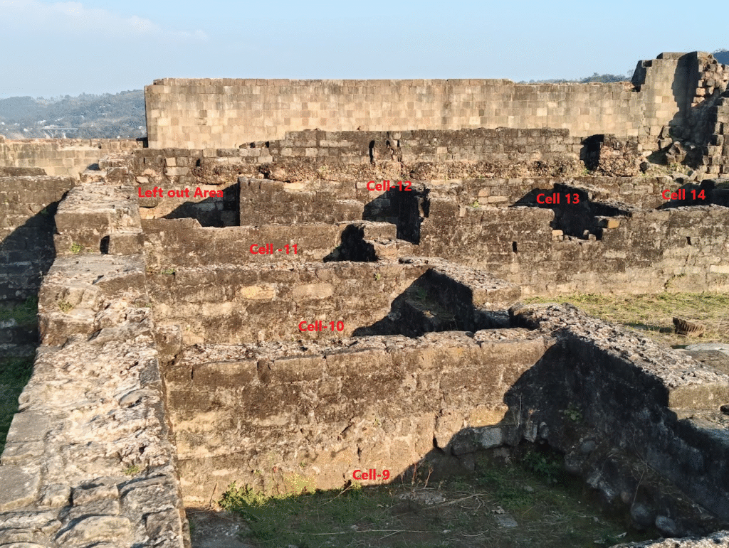
Figure-7 : Cells Nos 9 to 14.
Further the repetitive arrangement of small uniform cells around the courtyard strongly suggests monastic use(Figure:2&7). This kind of near-uniformity of the cells closely resembles all early Buddhist sites in northern India and the Himalayan region. The layout also indicates a singular and controlled entry into the courtyard space. The overall courtyard layout and construction technique used give a fortified outlook to the complex which was also another common feature in the Kushana Era monastic layout (Payne and King 2020).
The monastic cells at present site exhibit a strong uniformity in size . The irregular triangular space at the southwestern corner of the courtyard appears to have been deliberately left unoccupied between Cells 1 and 20, Cells 17 and 16, and Cells 11 and 12, in order to maintain the uniform dimensions of the surrounding residential cells ( Figure:7). The standardized dimensions of the cells likely reflect the monastic principle of equality among monks.
Chamber-A may be seen as an assembly hall due to its large size; such an assembly hall was common in Buddhist vihāra and meant for the assembly of monks. Assembly Chambers were added to the monastic layout to enable monks meetings, prayers and philosophical discussions. Chamber-B & C might be other utility rooms such as kitchen and bathroom , these architecture components are observed in other monasteries also. The cubic blocks inside the chambers A and B either support the second story or roof.
The complex is architecturally simple and presently lacks any visible stupa within the preserved remains. It is documented that early Buddhist monasteries frequently existed without incorporating the stupa within the residential courtyard. A similar trend was also noted in monasteries of North-West India where monasteries omitted the construction of Chaitya in favor of Vihara (Fogelin 2015, 128).
Two wells presented at the studied complex are in a bell shape and are lined internally with sandstone bricks that cover the walls and the floor. The bell shape and relatively narrow openings of these wells suggest that they may not have been intended for water extraction. The geological setting of the site further supports this interpretation. The fort is situated on top of elevated hills composed mainly of Shivalik conglomerate formations, which generally limit the availability of groundwater. Moreover, the two wells are located only a few meters from each other, which makes it unlikely that they were constructed for water supply purposes. It is suggested that these wells were used for storage purposes and were constructed during fortification.
There is a vast Northern Ruined Section on the eastern side (Image:6). One particular feature of the section is Terrain cut structure having depth of approximately 1.5 m to 2m. Fragments of old structures such as large monolithic pillars and big blocks can be seen here. These fragments may represent an old religious structure. There is also a possibility that this section may also be used as a pathway to the complex. Further detailed archaeological investigation is required to determine the precise nature and function of this section.
Hindu and Jain Temple complex located near the pathway and raised platform and temple attached with Chamber-A appears spatially differentiated from the main quadrangular block due to construction style and material. These structures suggest later religious adaptation or reuse of existing material.
Phases of Development
Based on the architectural layout, the eastern section of the complex appears to have developed through multiple phases of construction and modification. At least two major phases, along with possible intermediate stages of repair and alteration, can be inferred from the structural arrangement within the complex.
The earliest phase (Phase-I) may tentatively be assigned to the Kushana period, approximately 200–300 CE. This tentative dating is primarily based on the layout style and its close resemblance to early Buddhist monastic establishments in northern India and the northwestern Himalayan region. The Chetru Stupa near Dharamshala, which has also been attributed to the Kushana period (Archaeological Survey of India 2002), indicates that Buddhist activity was present in this region during that time.
Monasteries of the Kushana period were generally modest in scale, often enclosed within fortified boundaries ,arranged in a quadrangular pattern around a central courtyard and accessed through a single controlled entrance (Payne and King 2020, 1). The central courtyard surrounded by 20 small cells along with Chambers A, B and C at the present site correspond closely with these characteristics.
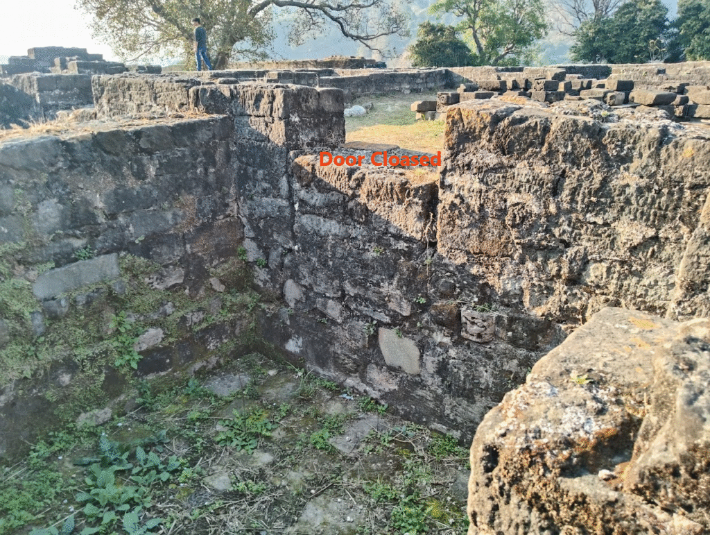
Figure-8 : Cells Nos 18.
The outer enclosure wall measures approximately 1 meter in thickness, while the internal partition walls are about 0.5 m wide. Such wall proportions suggest a fortified outer boundary combined with lighter internal divisions for residential spaces.
Between Phase 1 and Phase 2, there is evidence of repurposing of earlier cells. This indicates that modifications to the cells began prior to the Fortification of the complex. During this intermediate phase, the doorways of several cells appear to have been deliberately blocked, marking a change in their original function. This interpretation is further supported by the later construction of wells during Phase 2, which were built directly over some of the cells. If the cells had remained in use, such construction of wells alongwith closure of cell have been impractical, indicating that they had already been abandoned or functionally transformed before the introduction of the wells.
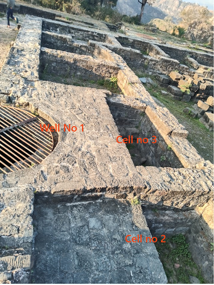
Figure-9 : Well no 1 and Cell no 2 & 3.
Comparative studies of Gandhāran monasteries show that during later phases of development (c. 300–500 CE), particularly with the increasing emphasis on image-based worship, earlier monastic cells were frequently modified. Such modifications often included the closure of entrances and the conversion of cells into shrines or auxiliary spaces (Sir John Marshall 1951, 286). The observed alterations at the present site may reflect a similar process of functional transformation.
Phase 2 of development appears to coincide with the fortification of the complex and may be tentatively dated to 800–1000 CE, in line with existing historical and archaeological interpretations (Ashvini Agrawal and C. Dorje 2016, 5). During Phase-2 the wells were introduced. Similarly construction of well no 2 suggests that the Terrain cut section was already ruined. During this period the Palace and other parts of the fort were constructed.
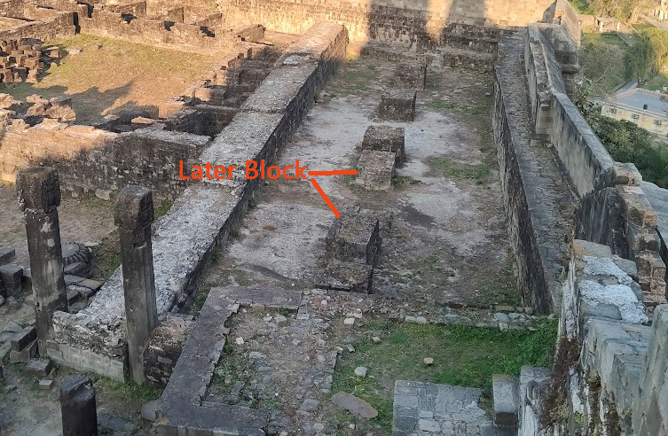
Figure-10 : Chamber-A with structural Blocks.
In addition to this the presence of multiple architectural elements reused across different parts of the complex indicates multiple phases of construction, modification, and reuse and materials appear to have been incorporated at different times, making it difficult to establish a clear chronological sequence based solely on surface observations. Therefore, a more detailed and systematic archaeological investigation is required to understand the actual sequence of development and transformation of the site.
Comparison with other Monastic Layout
The proposed monastery complex in Kangra is situated on an elevated hilltop outside the main urban core, occupying a topographic position. The site selection closely parallels the locational logic observed in North-Western Buddhist centres. Archaeological evidence from Taxila demonstrates that vihāra were consistently established at some distance from the city, typically on elevated hills overlooking the urban landscape (Payne and King 2020, 3). This pattern broadly accords with Vinaya prescriptions, which recommend that monastic establishments be located in raised and relatively secluded settings.
However, the architectural character of these monasteries complicates a purely aesthetic interpretation of elevated siting. Excavated vihāra from Taxila, as well as later examples from Central Asia and Central Tibet reveal compact, inward-oriented, and in some cases Fortified layouts (Behrendt 2004). These structures are typically defined by thick outer walls, minimal external openings, and controlled entry through a single narrow doorway (Figure:11). Such features indicate that elevation was not intended merely for scenic advantage, but also served practical purposes including security, surveillance, and spatial isolation. Therefore it is suggested that the Kangra hilltop monastery reflects both geographical and functional continuity with the North-Western monastic tradition.
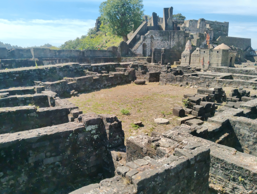
Figure-11 : Courtyard with surrounding cells.
In terms of architectural form, Buddhist monasteries were primarily residential institutions designed to accommodate monastic communities and facilitate religious practices such as study, meditation, and ritual activity (Dharkar 2019, 778). Archaeological and textual evidence indicates that early vihāra commonly followed a quadrangular cloister plan organized around a central open courtyard. Monastic cells were arranged along the inner faces of enclosing walls, generally opening inward toward the courtyard and often connected by verandas or corridors (Dharkar 2019, 12). This inward-looking arrangement fostered controlled communal interaction while limiting external engagement.
Studies of Kushana-period monasteries in Gandhāran and adjoining regions further demonstrate the widespread adoption of this layout in Himalayan belt (Hāṇḍā 1994, 25). Sites such as Khāder Mohrā, Pippala, Jauliāñ, and Mohra Moradu in the Taxila valley exhibit standardized quadrangular plans, with a central courtyard often containing a stūpa and surrounded by rows of monastic cells within a walled enclosure. The heavy external walls and restricted openings of these complexes often give them an outwardly fortified appearance (Sir John Marshall 1951).
Later developments of monasteries in the Gangetic plains visible at sites such as Nalanda, Sarnath, and Sanchi show a more formalized architectural evolution, where monastic cells are arranged around a courtyard with a shrine chamber or Buddha image placed along a fixed axial alignment. In contrast, earlier Gandhāran monasteries tend to exhibit simpler, integrated layouts in which residential and ritual functions coexist within a single enclosed space.
This comparative framework provides a strong basis for interpreting the structural and spatial logic of the proposed Kangra monastery within a broader trans-regional monastic tradition starting developing Kushana period onward.
Discussion
The evidence presented in this study suggests that the core section of Kangra Fort may represent the remains of an earlier Buddhist monastic complex that predates the fortification phase. The quadrangular layout, characterized by a central courtyard surrounded by uniform cells, controlled access, thick outer walls, and elevated location, closely corresponds with established monastic planning traditions of north-western India. These features indicate that the site was not originally conceived as a purely defensive structure but reflects a residential and institutional architectural logic consistent with Buddhist vihāras.
Comparative analysis, along with regional evidence from Buddhist monastic sites such as Chetru near Dharamshala, suggests that the monastic phase of the site may tentatively be assigned to the Kushana period (c. 200–300 CE). During this period, such courtyard-based monastic layouts became widespread across the north-western region. The architectural organization and spatial hierarchy observed at the site also align with broader patterns of monastic development outlined by Behrendt (2004) indicating a stage of evolution in which residential, ritual, and institutional functions were integrated within a single enclosed complex.
At a later stage, the site appears to have undergone functional transformation. During the period of political instability in north-western India, particularly in the context of conflict between the Hindu-Shahi rulers and the advancing Turkish forces, the site may have been repurposed for strategic use. It is possible that, during the reign of Bhimadeva, the complex was adapted as a treasury. This interpretation is supported by the recovery of numerous Hindu Shahi coins from Kangra Fort, as well as the historical association of the region with the name “Bhimnagar” (Abdur Rehman 1976, 21)
The architectural fabric of the site preserves clear evidence of multiple phases of construction, repair, and reuse. Visible variations in wall thickness within the cells indicate successive rebuilding episodes, while the addition of extra structural blocks within Chamber-A suggests attempts at structural reinforcement rather than post-collapse reconstruction. Such interventions imply continued occupation and adaptation of the complex over time, rather than a single phase of abandonment and rebuilding.
Although direct material evidence remains limited, there are indications that the site may also have been associated with later tantric practices. This possibility is consistent with the wider pattern observed in the Himalayan region, where Buddhist monastic sites increasingly engaged with tantric traditions from the early medieval period onward. However, this aspect remains tentative and requires further archaeological verification.
The transformation of the site must also be understood within the broader context of political and cultural change in north-western India. Large-scale disruptions, including the Hunic incursions during the 5th–6th centuries CE, may have contributed to the decline of earlier Buddhist establishments (Hāṇḍā 1994; Singh 2017). In subsequent centuries, evidence from north-western India and Afghanistan indicates that monastic and religious complexes were occasionally adapted into fortified structures during periods of conflict (Khan et al. 2021). The reuse of the Kangra site as a fort may represent a local manifestation of this wider historical process of architectural evolution.
Limitations of the Study
This study is based entirely on surface observations and remote spatial analysis, without stratigraphic data, absolute dating, or artefact-based evidence. Accordingly, chronological attribution remains provisional, and the functional interpretation should be regarded as a working hypothesis rather than a confirmed identification. Moreover, the presence of overlapping structures and multiple phases of construction and repair highlights the need for detailed, multidisciplinary investigation.
Conclusion
The fortified site in District Kangra presents strong preliminary evidence of an earlier Buddhist monastic occupation underlying a later Fortification. The layout of the complex closely corresponds with known Buddhist monastic plans of the Kushana period. Although definitive conclusions require systematic archaeological investigation, the architectural logic strongly supports a monastic origin. The identification and study of such sites are crucial for reconstructing the religious and cultural landscape of the Shivalik foothills during the early historic period.
Acknowledgements
The author expresses sincere thanks to Aditya Verma for his support in layout map development and for providing site photographs used in this study.
References:
Abdur Rehman. 1976. The Last Two Dynasties of The Shahis.
Available at: http://archive.org/details/tltd_20240114
Archaeological Survey of India. 2002. Indian Archaeology 1996–97: A Review. New Delhi.
Available at: https://nmma.nic.in/nmma/NAS1/nmma_doc/IAR/Indian%20Archaeology%201996_97%20A%20Review.pdf
Ashvini Agrawal and C. Dorje. 2016. Kangra Fort. Archaeological Survey of India.
Available at: http://archive.org/details/kangrafort00ashv
Behrendt, Kurt A. 2004. The Buddhist Architecture of Gandhara. Brill.
https://archive.org/details/buddhistarchitec0000behr
Cunningham, Alexander. 1875. Report for the Year 1872–73, Vol. V.
Available at: http://archive.org/details/in.ernet.dli.2015.63205
Dharkar, Ekta P. 2019. “Structural Vihar: Abode of Buddhist Monks…” Heritage Journal.
https://www.heritageuniversityofkerala.com/JournalPDF/Volume7/49.pdf
Fogelin, Lars. 2015. An Archaeological History of Indian Buddhism. Oxford University Press.
Google Earth. 2026. Satellite View of Kangra Fort.
Available at: https://earth.google.com
Gray, David B. 2016. “Tantra and the Tantric Traditions…”
Available at: https://doi.org/10.1093/acrefore/9780199340378.013.59
Handa, Devendra. 2007. Tribal Coins of Ancient India. Aryan Books International.
Handa, Omacanda. 1994. Buddhist Art & Antiquities of Himachal Pradesh.
Khan et al. 2021. “Investigating the Hindu Shahi Kingdom…” Journal of Asian Civilizations.
Mahavamsa. Chapter XII.
Available at: https://lakdiva.org.lk/mahavamsa/chap012.html
Payne & King. 2020. The Limits of Empire in Ancient Afghanistan.
Singh, Upinder. 2017. Political Violence in Ancient India. Harvard University Press.
Sir Aurel Stein. 1892. Kalhana’s Rajatarangini.
Available at: http://archive.org
Sir John Marshall. 1951. Taxila: Archaeological Excavations.
Vogel, J. Ph. 1933. History of the Panjab Hill States.
Available at: http://archive.org/details/in.ernet.dli.2015.38533