Note:- 3d Map of Lakes of Himachal Pradesh is Also given in end for deep insight
Lakes of Himachal Pradesh
Himachal Pradesh has vast number of Lakes. Majority of Lakesh are fresh water lakes and of Glacier origin and located in higher altitude of Himalaya.There are also few man made and tectonic Lakes. The lakes of Himachal can also be classified on the basin of Mountain system in which they located.
Types of Lakes Himachal Pradesh.
A) Glacier origin Lakes: Such Lakes are located in higher altitude of Dhauladhar, Pirpanjal and Greater Himalaya.
Example:- Suraj Tal , Chandar Tal, Mantalai Lake and Sopna Lakes of Greater Himalaya. Similarly Mahakali Lake, Gadasru Lake, Bhrigu Lake, Manimahesh Lake of Pirpnajl and Lam Dal Lake of Dhauladhar Mountain.
- Ghadasru Lakes- It is the northenn most major lakes of Himachal Pradesh, It is located on the boundary of Chamba and Lahaul Spti. It is located on Pirpanjal mountain range and has roughly height of 3500 Mts. The Lake is very sacred for Hindus. It is Part of Ravi river Basin( Source- Geography of Himachal Throuh Maps,Pardeep Kumar). Mahakali lake is other important lakes , located near it.
- Suraj tal and Chandar Tal Both are Glacier formed Lakes. Both Lakes are located on Greater Himalaya.
B) Tectonic Lakes:- These lakes are of Tectonic origin i.e They formed due to Tectonic activities for example:-
- Renuka Lake formed due to activation of Giri Thrust (MBT), Kareri Lake, Dal Lake and Rewalsar groups of Lakes are also formed in Tectonic trough.
C) Man Made Lakes:-These Lakes are formed due to construction of barrage in path of river. Bhakhara Dam and Pong Dam etc. are example of man made Lakes
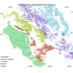
Lakes of Himachal Pradesh with District Map in Backgrounds

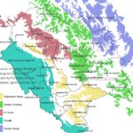
Lakes of Himachal Pradesh with Mountain Range in Background
Lakes and Mountain Ranges, Himachal Pradesh
- Shivalik Range– Pong Lake in Kangra
- Dhauladhar Mountain Range-Khajjiar Lakes, Lamdal Lakes, Kareri Lake,Tannu Jubbal Lake, Kamrunag, Chandekup lake etc.
- Pirpanjal- Ghadasaru lake, Manimahesh Lake, Dashar and Bhrigu Lakes
- Greater Himalaya Lakes– Suraj Tal,Chander Tal and Mantalai etc.
Map based Question of Lakes Himachal Pradesh
Analysis: *Majority of Glacier Lakes are located in Greater Himalaya mountain range and fed by precipitation brought by Western Disturbance. Majority of lakes of Greater Himalaya and higher Lesser Himalaya share common formation process. Whereas most lakes of Shivalik are either man made or are of tectonic in nature.*Ghadasaru is northernmost major lake of Himachal Pradesh, whereas Renuka is southernmost of HImachal Pradesh.*Khajjiar, Kareri, Lam Dal, Prashar, Kamrunag, Chandarnahan and Tan Jubbal etc are located in Dhauladhar, where as Suraj Tal, ChanderTal, Mantalai are located in Greater Himalaya.*Suraj Tal and Renuka lake are on roughly same Longitude, similarly many lakes share same longitude and Latitudes(find more such a lakes).*
Source:- Himachal Pradesh Geography Through Maps by Pardeep Kumar.
(Amazon buying linhttps://www.amazon.in/Himachal-Pradesh-Geography-Through-Maps/dp/B0FJ2R4B4P)
In Below Map zom at Major Thrust and Location of Lakes. Observed the Renuka Lakes, Rewalsar Lakes, Kareri Lake etc
3d Map of Tectonic Lake of Renuka, District Sirmaur, Himachal Pradesh
On above 3d model you can see , Yellow Color is Paleo rive channel of river Giri, which is now Renuka lake.
