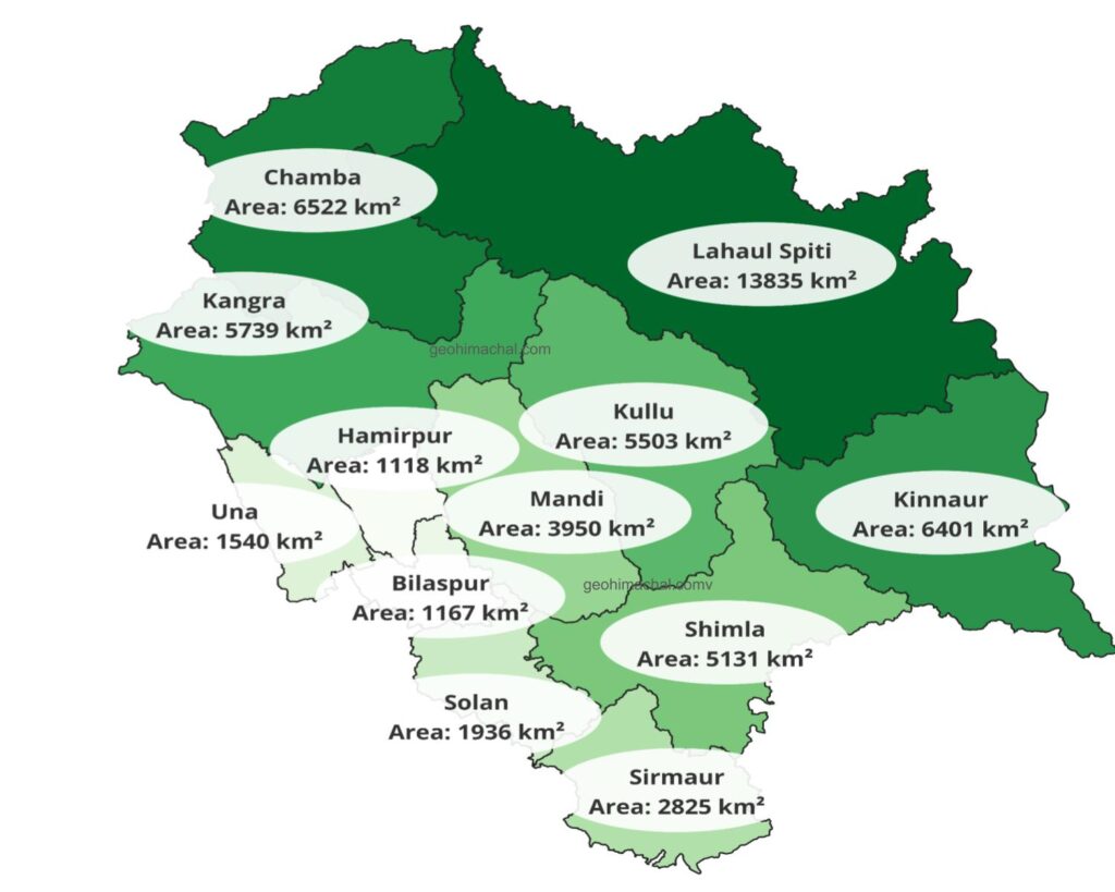
Geographical Location of District Kullu
- Kullu valley is a wide and open valley , where lesser Himalaya transitioned to Greater Himalaya. Dhauladhar, Pir Panjal and Greater Himalayan are main mountain ranges of district. Total area of district is 5503 Sq Km. District is bounded by Lahaul Spiti in North, Kinnaur in East, Kangra in North west , Mandi in West and Shimla in South.
- Kullu is a vast valley surrounded by Greater Himalaya, Pir panjal and Dhauladhar mountain range.District has two important valleys Beas valley and Satluj valley. Both are connected by Jalori Pass, which is located on ridge of which connect lesser Himalayan Dhauladhar mountain range with Greater Himalaya.( see below give map)
Below is Detailed map of District Kullu.
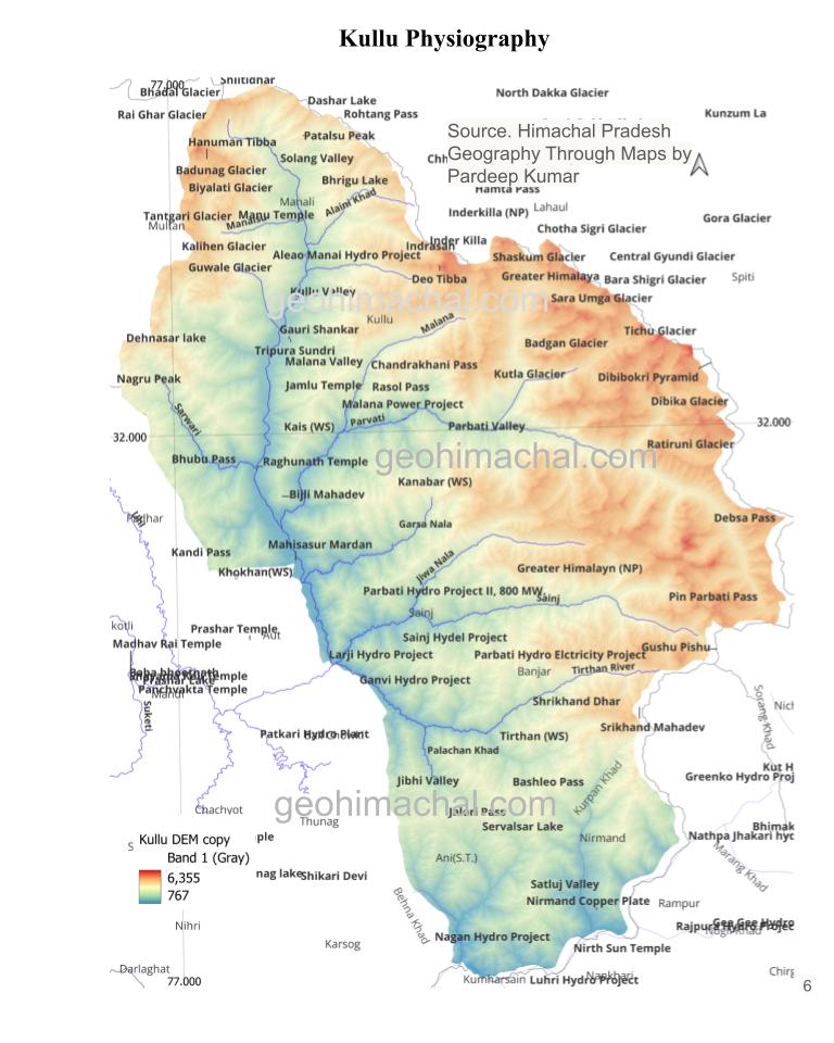
Mountain Ranges of District Kullu, Himachal Pradesh.
- Pir Panjal range enter the district from North west and continue toward South east. In North and West it formed the boundary with Bara Bhangal and Lahaul.
- There are many important peaks such as Hanuman tibba, Patalsu, indrasan, Deo tibba and Inder killa etc. Rohtang pass , Hamta pass and Makori pass are located on this range. Beas kund, Bhrigu lake and Dhashar lake are also located here.( for more details: Maps of Passes of Himachal Pradesh)
- Dhauladhar like Pir Panjal transverse from west to east. It formed the boundary with Mandi. Famous Jalori Pass and Bhubu pass located on this range. In Aut Dhauladhar cut through by Beas, where it form the famous Larji Gorge.
- Greater Himalayan Range passes through the eastern part of the district and formed the boundary with Spiti and Kinnaur. It is high mountain range. Both Pir Panjal range and Greater Himalayan range merge gradually in eastern part of District and Pirpanjal eventually lost its identity.
- Ali ratni Dhar 5269 meter, Ghondli Dhar 4221 meter,Dharing Dhar 4183 mtr and Sirkhand Dhar 5160 meter are important local Dhar of region. This zone is marked by towering peaks and permanent Glaciers. Reason of such high peaks and altitude is merger Himalayan National Park is also located here.
Valleys of Kullu, District Kullu, H.P
- Kullu valley is located in midst of Pir Panjal range, Dhauladhar and Greater Himalayan Mountain range. River Beas pass from the mid of the valley. Valley is believed to be a vast lake , formed due to rise of lesser Himalaya(Dhauladhar) in Southern part, where river still form Deep gorge and V Shaped valley. Larji gorges where Beas river take Turn into Mandi is 2050 Mtr deep.( See valley map Below)
 Valley is narrow in north and became wide in middle parts whereas in Southern part it again became narrow and ultimately turned into Deep Gorges.
- Kullu valley, Garsa valley, Manikaran valley, Lag valley, Solang valley,Malana valley, Parvati valley and Jibhi valleys are few important valleys and attract thousands of tourist every year.
Satluj valley located on South Eastern part of district ,Greater Himalayan range separate it from main Kullu valley. Jalori pass served as only connecting link between two valleys. Nirmand and Ani are two important settlements of Satluj valley. Unlike Beas valley , Satluj valley is very narrow and deep.
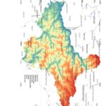
Drainage System of Kullu.
Beas River
Geology of District Kullu, Himachal Pradesh
Geologically rocks of District Kullu range from the Paleoproterozoic to Jurassic age. Most important Group of Rock is Vaikrita Group, Rampur Group and Kullu group.