Source: Himachal Pradesh Geography Through Maps and H.P. Geography by Pardeep Kumar. Content owned and rights reserved by the author and site owner.
Location of District Una
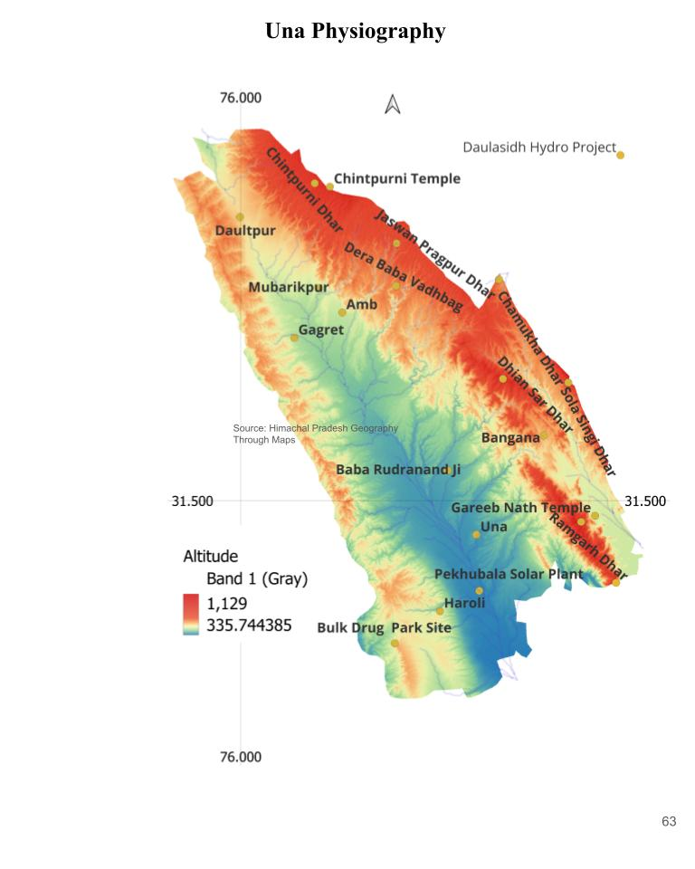
Total area of Una is about 1540 Sq km whole district fall in Shivalik hills. District is bordered by Kangra in north and north east, Hamirpur on east, Bilaspur on south and Punjab on west.General elevation of district range from 337 Mt to 1105 Mt. North Western & Eastern part of district have high elevation and elevation decrease toward central and southern part of district. Physiographically district can be divided into
- Shivalik hills, denuded hillocks, Flood Plains and Piedmont Plains .
Physiographic Map of Una.
Shivalik Hills
- In North & North East, district is surrounded by Shivalik ranges, running North west to South East with gradual increase of altitude toward east. In fact these ranges are part of same mountain ranges that rises from Kangra. A small mountain range enter the district as Chintpurni Dhar in village Ghangret, it is principal mountain range of district, Chintpurni dhar continue toward South east as Jaswan Dhar and further east as Solah Singhi Dhar. This mountain range formed the natural border with Kangra, Hamirpur and Bilaspur. Solah Singhi Dhar is the also highest geographical part of District.
- Shivalik lack any major Industries but they known for supplying essential raw material for Katha Udhyog in district. There are many old Katha Udhyog industries just in Plain just near Shivalik.
Western Hillocks
- Western part of district along the Punjab border is also a hilly tract, however altitude of these hills never exceed 600 mtr. The whole tract is very fragile and actively eroded by numerous monsoonal streams. In fact hills of Una in general are very susceptible to erosion and one can easily encounter Rill, Gully and Ravine . In monsoon local streams known as Choos (a kind of Ravine/Gully) cause widespread Splash flood in the district, specially in Gagret, Amb, Haroli and Una blocks.Sedimentary loosely assembled conglomerates or sandstone with relatively young age made the district very prone to erosion.
- Since these hillock has scanty vegetation and mainly composed of throne and bushes, this areas has become active industrial centre zone in District. These hills are mined for excessively for sands, there are nearly 80 stone crusher in district.
- Due to cheap price of Land many Private sector companies has established their manufacturing plant here. Bathari Industrial Area ,Basal Industrial area and Haroli industrial area all are located here. Central Govt has sanction the construction of Bulk Drug Park in Beetan Haroli in 2022 , it is one of the three Bulk Drug park of India.
- Easy Land availbility, cheap constuction material, cheap labor and accessibility with Punjab made this area suitable for large industries and whole region in turning into large industrial zone.
Flood Plains.
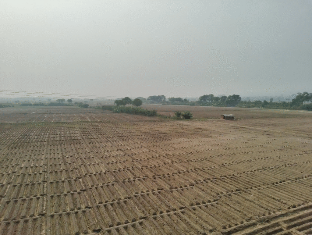
- Central part of district is surrounded by mountain from three sides, making it largest Doon valley of Himachal(App.600 Sq km). Numerous meandering streams originating from two side deposits fresh alluvial in every Monsoon. The Una Doon is very narrow in Northern side (3 km) and become wider toward south (15 km). These Plains are very fertile. The soil is sandy and light brown in color which is good for wheat, Potato and sugarcane cultivation. General elevations of Plain decrease toward South East. This make whole district very susceptible to flooding.
- Swan river and its tributories has created elevated flood plain along both side of course. These plains are not very fertile (Bhabar) and has coarse sand with peeble and gravels. Thus this land is either used for mining or for industrial purpose. But Land beyond this coarse plain is very fertile (Khadar).
Piedmont Plains
- Foothills of Shivalik are zone of fertile Piedmont plain formed due to active erosion and deposition. Soils of these Piedmont plain is very sandy, deep and fertile. It support the good root penetration and aeration however it is subjected to severe erosion. These plains are extensively exploited by farmers for the cultivation of Wheat, Potato and Sugarcane etc.
District Una and Govind Sagar Reservoir
Bearing the northern part of district almost all area fall within Satluj catchment. Area between Solah Singhi Dhar and Dhian sar Dhar & Ramgarh Dhar is part of Govind Sagar Reservoir.( Lunkhar river drained this part)
Swan River and Landforms
- Swan is the largest and the longest river of district. Swan is a Surface River, cut the district longitudinally almost in two equal parts. It is among the widest river of hills. River is still in very young age, meandering loops and numerous Oxbow lake prove its youthfulness.
- During Monsoon season it actively engaged in lateral erosions, engulfing the fertile land and causing large scale flood in district. This is the reason river is also known as Sorrow of Una. To Stop the further land loss number of river channelization project are being undertaken by Govt. ( for detail see it Complete Satluj, Beas, Ravi, Chandrabhga, Tons River system a Map based Study.(Part-2))
- Among the most notable featrure of District is agricultural practice along the Swan river bank. In winter and Summer , Swan river get dry to great extent. Migrant people from other state Ploughed the rivers reclaimed the land and convert it to excellant agri field. These agrifield are very fertile as it received fertile soil in every monsoon. Migrant here grow mainly Potato and Tomato. Apart from this wooden and Grass hut in these agrifield add unique element to landscape.
Geology
- Geological history of district is closely linked with development of Main Frontal Thrust(MFT). District is delineated from Great Indian Plains by MFT in South and Soan and Badsar thrust in North. After the rise of Greater Himalaya 20-23 MYA , a forehand basin developed in south of it.
- Rise of Greater Himalaya also mark the onset of Monsoon which further intensified the process of erosion. Numerous rivers flowing from Greater Himalaya deposited the sediments that later uplifted/ thrust and resulted into hills. District is still a very active Depo Center, receiving sediments from all around.
Geologically rocks are classified in Sub Himalayan Sequence. Both Janauri Anticline and Bharwain Anticline represent the Upper Siwalik formation with loosely assembled rocks. Whereas Una syncline represent the Quaternary deposit.