Himachal Pradesh has both Antecedent and Consequent Streams. Satluj is an antecedent which mean it exist before the rise of Himalaya, similarly Chenab, Beas, Ravi etc are consequent streams, which make Himachal ideal state to study river Hydrology. Further Himachal Pradesh is drained into both Arabian Sea and Bay of Bengal, a ridge emerging near Narkanda follow downward passes from Ridge ground of Shimla is water divided between Bay of Bengal and Arabian Sea. ( Read full Table and Data here).
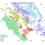
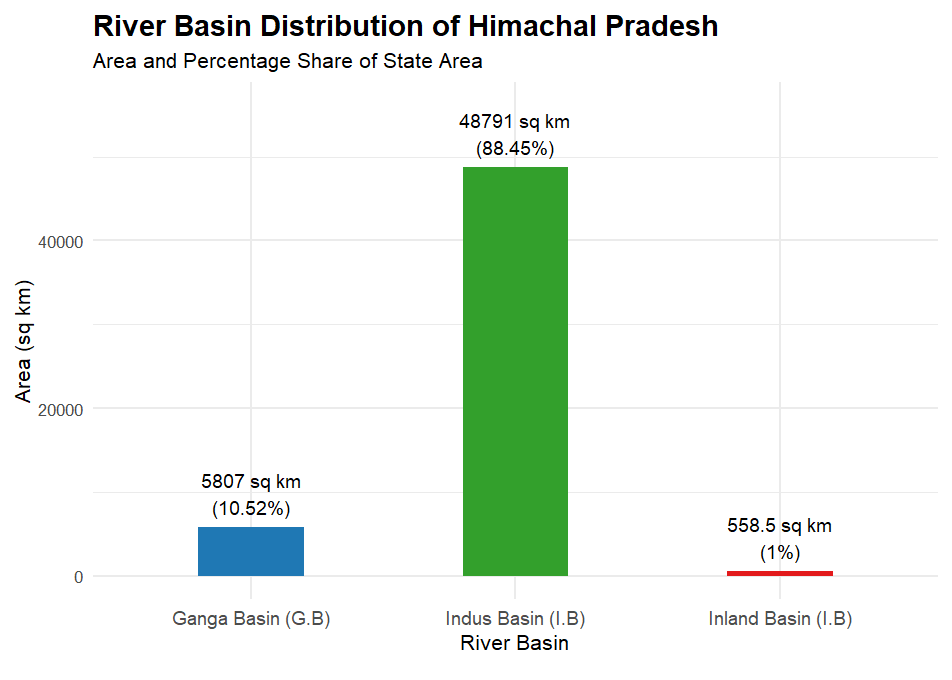
Below Graph is showing Indus basin, Ganga basin and inland basin in Himachal Pradesh
Tables Showing Details of Each river Basin in State of Himachal Pradesh.
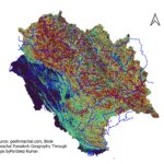
Source: Himachal Pradesh Geography Through Maps by Pardeep Kumar. Amazon Buying Link https://www.amazon.in/Himachal-Pradesh-Geography-Through-Maps/dp/B0FJ2R4B4P
Details of Rivers basin Himachal Pradesh:-
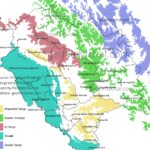
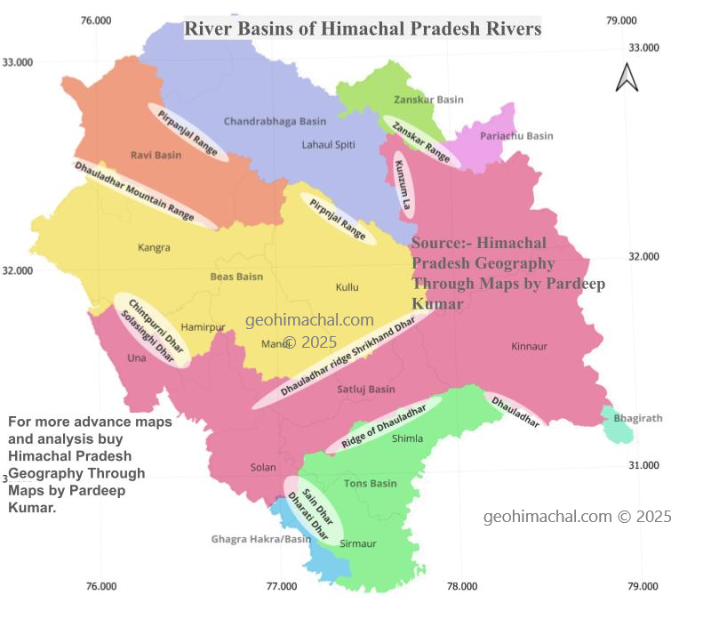
Himachal Pradesh has vast network of small and large rivers, Ranging from consequent stream to antecedent streams. Density of such vast rivers network indicate the early youthfulness of Himalaya and its rivers network. River Like Satluj exist long before the existence of Himalaya itself. The evolution of these rivers are closely link with evolution of Himalayan ranges. Each river basin is separated from other river basin by either a mountain range or a crest of mountain.
For example: In District Lahaul Spiti the Zanskar river basin is separated from Chandrabhaga river basin from Zanskar mountain range, similarly Kunzum mountain range separate the Chandrabhaga basin from Spiti river basin. Pirpnajan range which also formed the boundary between Lahaul Spiti and Chamba also formed the boundary between Ravi Basin and Chandrabhaga basin.
The Dhauladhar mountain range not only formed the boundary between Chamba and Kangra but also Ravi and Beas Bain. Similarly in Shivaliks hills, famous Chintpurni Dhar seprate the Beas Basin from Satluj Basin in District Una.
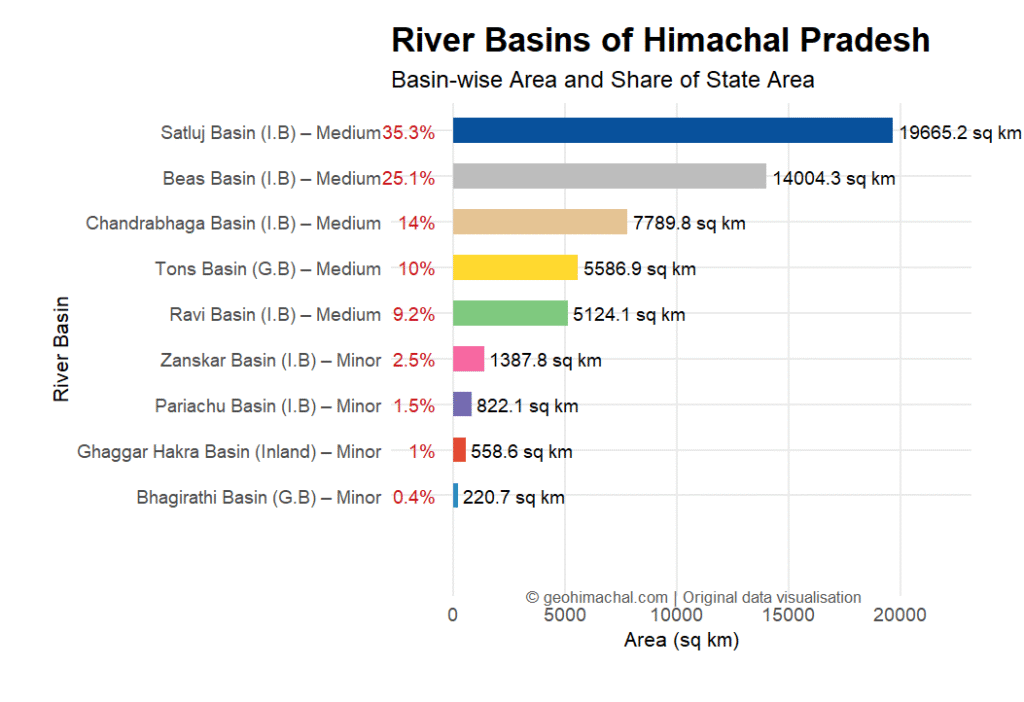
Area covered by Different River Basins.
Satluj River Basin is the Largest river Basin of Himachal Pradesh , it cover roughly drain 35.3% area of State , it is followed by Beas river which drain the 25.10% area of state. Chandrabhaga and Ravi each drain the 14% and 9.20 % of State area. All previously mention rivers are part of Indus river system. Two minor Sub -basins of Indus river in State are Zanskar ,which cover roughly 2.50% of State area and Pariachu river ,which is tributroy of Satluj cover 1.50 % area of State. In Total Indus river cover roughly 48791 Sq Km, which 88.45% of State Area. ( See- below Mention Table)
Tons river drained the part of Shimla, Solan and Sirmaur District, it drained roughly 10 % of State. Less mentioned and documented is Bhahirathi Basin, which drained 220.74 Sq Km (0.40 %) of State. In all Ganga Basin cover 5807 Sq Km of State , which is around 10.52 % of State area.
Besides all these 558.5 Sq .km of District Solan and Sirmaur is part of Ghagra and Hakra inland Basin.
Part 2 Rivers System of Himachal Pradesh ( Ravi, Chandrabhaga, Beas, Satluj and Tons) with Map (Part-2)
Based on approx. areas, which basin is the smallest?
a) Ghaggar Hakra
b) Bhagirathi
c) Pariachu
d) Zanskar
Answer: b) Bhagirathi
The Satluj Basin covers approx. 19,665 sq km. What is its size?
a) approx. 14,004 sq km
b) approx. 7,790 sq km
c) approx. 19,665 sq km
d) approx. 5,124 sq km
Answer: c) approx. 19,665 sq km
Which basin covers approx. 25.10% of the state area?
a) Beas Basin
b) Ravi Basin
c) Chandrabhaga Basin
d) Tons Basin
Answer: a) Beas Basin
The Chandrabhaga Basin area is approx.:
a) approx. 7,790 sq km
b) approx. 5,124 sq km
c) approx. 5,587 sq km
d) approx. 221 sq km
Answer: a) approx. 7,790 sq km
Which basin has the highest approx. percentage of state area?
a) Zanskar
b) Beas
c) Satluj
d) Chandrabhaga
Answer: c) Satluj
The Ravi Basin covers approx. what percent of the state?
a) approx. 10%
b) approx. 9.20%
c) approx. 14%
d) approx. 1%
Answer: b) approx. 9.20%
Which of the following is a minor basin (area values approx.)?
a) Chandrabhaga
b) Beas
c) Pariachu
d) Ravi
Answer: c) Pariachu
Which basin has an area of approx. 822 sq km?
a) Bhagirathi
b) Zanskar
c) Pariachu
d) Ghaggar Hakra
Answer: c) Pariachu
Which basin’s area is approx. 5,587 sq km?
a) Tons Basin
b) Ravi Basin
c) Ghaggar Hakra Basin
d) Chandrabhaga Basin
Answer: a) Tons Basin
Which basin covers approx. 2.50% of the state area?
a) Zanskar
b) Pariachu
c) Ghaggar Hakra
d) Bhagirathi
Answer: a) Zanskar
Which basin has an area of approx. 5,124 sq km?
a) Ravi Basin
b) Beas Basin
c) Chandrabhaga Basin
d) Tons Basin
Answer: a) Ravi Basin
What percent of the state area is covered by the Ghaggar Hakra Basin (approx.)?
a) approx. 2.50%
b) approx. 1%
c) approx. 1.50%
d) approx. 0.40%
Answer: b) approx. 1%
Which is the only basin with less than approx. 1% state coverage?
a) Bhagirathi Basin
b) Ghaggar Hakra Basin
c) Pariachu Basin
d) None
Answer: a) Bhagirathi Basin
What is the combined approx. percentage of Beas and Ravi basins?
a) approx. 33.30%
b) approx. 34.30%
c) approx. 35.10%
d) approx. 36.10%
Answer: b) approx. 34.30%
How many basins are classified as minor in the list (areas approx.)?
a) approx. 3
b) approx. 4
c) approx. 5
d) approx. 2
Answer: a) approx. 3